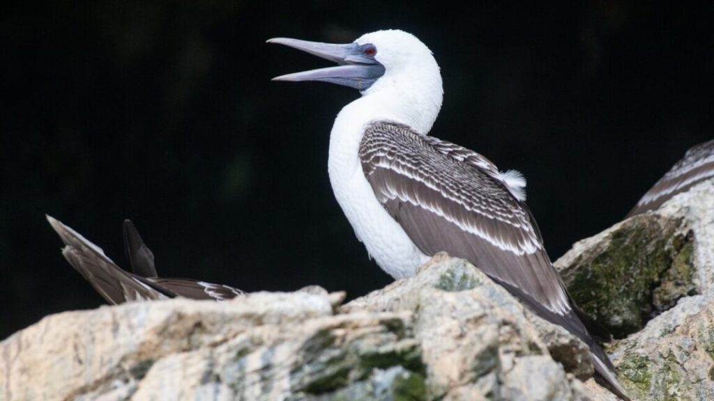
Now Bongers has turned his attention to analyzing the biochemical signatures of 35 maize samples excavated from buried tombs in the region. He and his co-authors found significantly higher levels of nitrogen in the maize than in the natural soil conditions, suggesting the Chincha used guano as a natural fertilizer. The guano from such birds as the guanay cormorant, the Peruvian pelican, and the Peruvian booby contains all the essential growing nutrients: nitrogen, phosphorus, and potassium. All three species are abundant on the Chincha Islands, all within 25 kilometers of the kingdom.
Those results were further bolstered by historical written sources describing how seabird guano was collected and its importance for trade and production of food. For instance, during colonial eras, groups would sail to nearby islands on rafts to collect bird droppings to use as crop fertilizer. The Lunahuana people in the Canete Valley just outside of Chincha were known to use bird guano in their fields, and the Inca valued the stuff so highly that it restricted access to the islands during breeding season and forbade the killing of the guano-producing birds on penalty of death.
The 19th-century Swiss naturalist Johann Jakob von Tschudi also reported observing the guano being used as fertilizer, with a fist-sized amount added to each plant before submerging entire fields in water. It was even imported to the US. The authors also pointed out that much of the iconography from Chincha and nearby valleys featured seabirds: textiles, ceramics, balance-beam scales, spindles, decorated gourds, adobe friezes and wall paintings, ceremonial wooden paddles, and gold and silver metalworks.
“The true power of the Chincha wasn’t just access to a resource; it was their mastery of a complex ecological system,” said co-author Jo Osborn of Texas A&M University. “They possessed the traditional knowledge to see the connection between marine and terrestrial life, and they turned that knowledge into the agricultural surplus that built their kingdom. Their art celebrates this connection, showing us that their power was rooted in ecological wisdom, not just gold or silver.”
Campylobacter is a common cause of food poisoning and is on the rise in Michigan and around the world. It spreads to humans through food products made from, or that come into contact with, infected animals, primarily chickens and other birds. So far, only one outbreak of campylobacteriosis has been definitively linked to feces from wild birds. Still, because it causes milder symptoms than some other types of bacteria, the Centers for Disease Control considers campylobacter a significantly underreported cause of food-borne illness that may be more common than current data indicates.
“Trying to get more birds of prey would be beneficial to farmers,” Smith said. “If you have one predator, versus a bunch of prey, you have fewer birds overall. If you have a lot fewer birds, even if the ones that are there are carrying bacteria, then you can reduce the transmission risk.”
The study’s findings that kestrels significantly reduce physical damage and food safety risks on Michigan cherry farms demonstrate that managing crops and meeting conservation goals—by bolstering local kestrel populations and eliminating the need to clear wildlife habitat around agricultural areas—can be done in tandem, study authors say. They recommend farmers facing pest-management issues consider building kestrel boxes, which cost about $100 per box and require minimal maintenance.
Whether nesting boxes in a given region will be successfully inhabited by kestrels depends on whether there is an abundance of the birds there. In Michigan’s cherry-growing region, kestrels are so abundant that 80 percent to 100 percent of boxes become home for kestrels rather than other nesting birds, said Catherine Lindell, avian ecologist at Michigan State University and senior author of the study.
“It seems like this is just a great tool for farmers,” Lindell said, suggesting interested farmers “put up a couple boxes and see what happens.”
K.R. Callaway is a reporter and editor specializing in science, health, history, and policy stories. She is currently pursuing a master’s degree in journalism at New York University, where she is part of the Science, Health, and Environmental Reporting Program (SHERP). Her writing has appeared in Scientific American, Sky & Telescope, Fast Company and Audubon Magazine, among others.
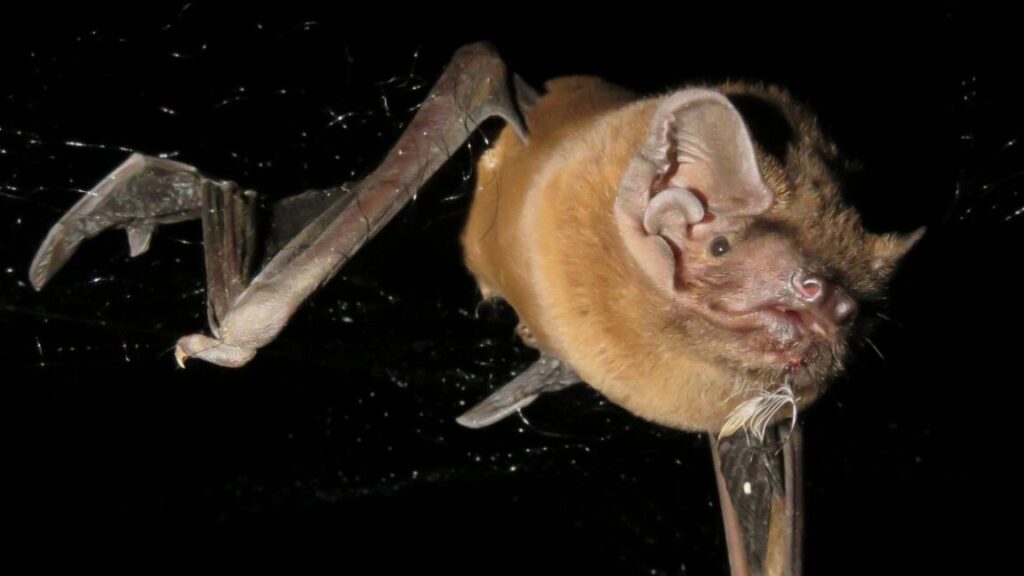
There are three species of bats that eat birds. We know that because we have found feathers and other avian remains in their feces. What we didn’t know was how exactly they hunt birds, which are quite a bit heavier, faster, and stronger than the insects bats usually dine on.
To find out, Elena Tena, a biologist at Doñana Biological Station in Seville, Spain, and her colleagues attached ultra-light sensors to Nyctalus Iasiopterus, the largest bats in Europe. What they found was jaw-droppingly brutal.
Inconspicuous interceptors
Nyctalus Iasiopterus, otherwise known as greater noctule bats, have a wingspan of about 45 centimeters. They have reddish-brown or chestnut fur with a slightly paler underside, and usually weigh around 40 to 60 grams. Despite that minimal weight, they are the largest of the three bat species known to eat birds, so the key challenge in getting a glimpse into the way they hunt was finding sensors light enough to not impede the bats’ flight.
Cameras, which are the usual go-to sensor, were out of the question. “Bats hunt at night, so you’d need night vision cameras, which together with batteries are too heavy for a bat to carry. Our sensors had to weigh below 10 percent of the weight of the bat—four to six grams,” Tena explained.
Tena and her team explored several alternative approaches throughout the last decade, including watching the bats from the ground or using military-grade radars. But even then, catching the hunting bats red-handed remained impossible.
In recent years, the technology and miniaturization finally caught up with Tena’s needs, and the team found the right sensors for the job and attached them to 14 greater noctule bats over the course of two years. The tags used in the study weighed around four grams, could run for several hours, and registered sound, altitude, and acceleration. This gave Tena and her colleagues a detailed picture of the bats’ behavior in the night sky. The recordings included both ambient environmental sounds and the ultra-frequency bursts bats use for echolocation. Combining altitude with accelerometer readouts enabled scientists to trace the bats’ movements through all their fast-paced turns, dives, and maneuvers.
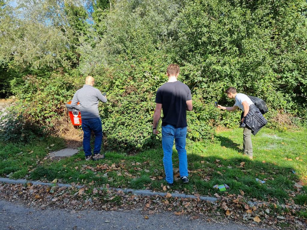
“It took us about 20 seconds to find the first one in an area indicated by the model,” wrote Jaffer in a blog post documenting the field test. Starting at Milton Community Centre, where the model showed high confidence of brambles near the car park, the team systematically visited locations with varying prediction levels.
The research team locating their first bramble. Credit: Sadiq Jaffer
At Milton Country Park, every high-confidence area they checked contained substantial bramble growth. When they investigated a residential hotspot, they found an empty plot overrun with brambles. Most amusingly, a major prediction in North Cambridge led them to Bramblefields Local Nature Reserve. True to its name, the area contained extensive bramble coverage.
The model reportedly performed best when detecting large, uncovered bramble patches visible from above. Smaller brambles under tree cover showed lower confidence scores—a logical limitation given the satellite’s overhead perspective. “Since TESSERA is learned representation from remote sensing data, it would make sense that bramble partially obscured from above might be harder to spot,” Jaffer explained.
An early experiment
While the researchers expressed enthusiasm over the early results, the bramble detection work represents a proof-of-concept that is still under active research. The model has not yet been published in a peer-reviewed journal, and the field validation described here was an informal test rather than a scientific study. The Cambridge team acknowledges these limitations and plans more systematic validation.
However, it’s still a relatively positive research application of neural network techniques that reminds us that the field of artificial intelligence is much larger than just generative AI models, such as ChatGPT, or video synthesis models.
Should the team’s research pan out, the simplicity of the bramble detector offers some practical advantages. Unlike more resource-intensive deep learning models, the system could potentially run on mobile devices, enabling real-time field validation. The team considered developing a phone-based active learning system that would enable field researchers to improve the model while verifying its predictions.
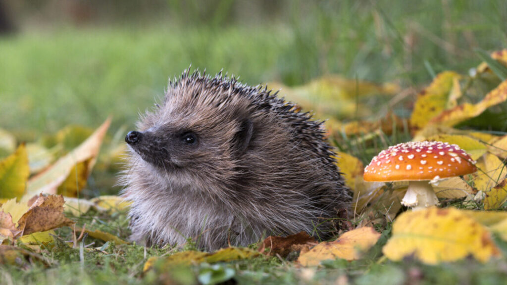
In the future, similar AI-based approaches combining satellite remote sensing with citizen science data could potentially map invasive species, track agricultural pests, or monitor changes in various ecosystems. For threatened species like hedgehogs, rapidly mapping critical habitat features becomes increasingly valuable during a time when climate change and urbanization are actively reshaping the places that hedgehogs like to call home.
McClain officially launched MOBS as a passion project while on sabbatical in 2022 but he had been informally collecting data on body size for various marine groups for several years before that. So he had a small set of data already to kick off the project, incorporating it all into a single large database with a consistent set format and style.
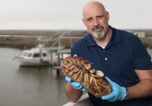
Craig McClain holding a giant isopod (Bathynomus giganteus), one of the deep sea’s most iconic crustaceans Credit: Craig McClain
“One of the things that had prevented me from doing this before was the taxonomy issue,” said McClain. “Say you wanted to get the body size for all [species] of octopuses. That was not something that was very well known unless some taxonomist happened to publish [that data]. And that data was likely not up-to-date because new species are [constantly] being described.”
However, in the last five to ten years, the World Register of Marine Species (WoRMS) was established with the objective of cataloging all marine life, with taxonomy experts assigned to specific groups to determine valid new species, which are then added to the data set with a specific numerical code. McClain tied his own dataset to that same code, making it quite easy to update MOBS as new species are added to WoRMS. McClain and his team were also able to gather body size data from various museum collections.
The MOBS database focuses on body length (a linear measurement) as opposed to body mass. “Almost every taxonomic description of a new species has some sort of linear measurement,” said McClain. “For most organisms, it’s a length, maybe a width, and if you’re really lucky you might get a height. It’s very rare for anything to be weighed unless it’s an objective of the study. So that data simply doesn’t exist.”
While all mammals generally have similar density, “If you compare the density of a sea slug, a nudibranch, versus a jellyfish, even though they have the same masses, their carbon contents are much different,” he said. “And a one-meter worm that’s a cylinder and a one-meter sea urchin that’s a sphere are fundamentally different weights and different kinds of organisms.” One solution for the latter is to convert to volume to account for shape differences. Length-to-weight ratios can also differ substantially for different marine animal groups. That’s why McClain hopes to compile a separate database for length-to-weight conversions.
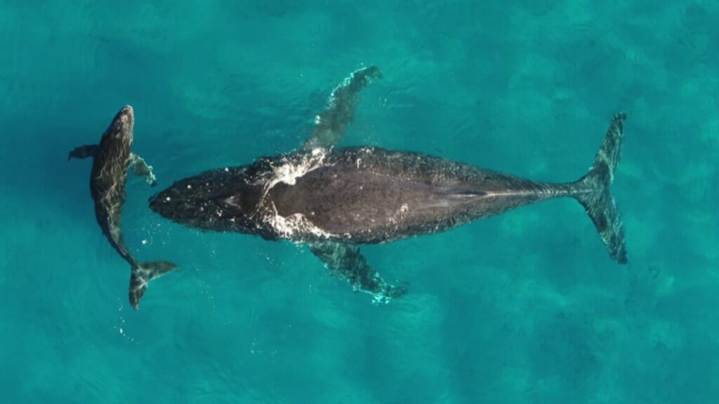
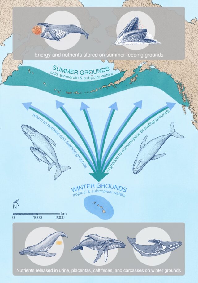
Migrating whales typically gorge in summers at higher latitudes to build up energy reserves to make the long migration to lower latitudes. It’s still unclear exactly why the whales migrate, but it’s likely that pregnant females in particular find it more beneficial to give birth and nurse their young in warm, shallow, sheltered areas—perhaps to protect their offspring from predators like killer whales. Warmer waters also keep the whale calves warm as they gradually develop their insulating layers of blubber. Some scientists think that whales might also migrate to molt their skin in those same warm, shallow waters.
Roman et al. examined publicly available spatial data for whale feeding and breeding grounds, augmented with sightings from airplane and ship surveys to fill in gaps in the data, then fed that data into their models for calculating nutrient transport. They focused on six species known to migrate seasonally over long distances from higher latitudes to lower latitudes: blue whales, fin whales, gray whales, humpback whales, and North Atlantic and southern right whales.
They found that whales can transport some 4,000 tons of nitrogen each year during their migrations, along with 45,000 tons of biomass—and those numbers could have been three times larger in earlier eras before industrial whaling depleted populations. “We call it the ‘great whale conveyor belt,’” Roman said. “It can also be thought of as a funnel, because whales feed over large areas, but they need to be in a relatively confined space to find a mate, breed, and give birth. At first, the calves don’t have the energy to travel long distances like the moms can.” The study did not include any effects from whales releasing feces or sloughing their skin, which would also contribute to the overall nutrient flux.
“Because of their size, whales are able to do things that no other animal does. They’re living life on a different scale,” said co-author Andrew Pershing, an oceanographer at the nonprofit organization Climate Central. “Nutrients are coming in from outside—and not from a river, but by these migrating animals. It’s super-cool, and changes how we think about ecosystems in the ocean. We don’t think of animals other than humans having an impact on a planetary scale, but the whales really do.”
“One of the more similar environments to the ISS was in the isolation dorms on the UCSD campus during the COVID-19 pandemic. All surfaces were continuously sterilized, so that microbial signatures would be erased by the time another person would show up,” Benitez said. So, one of the first solutions to the ISS microbial diversity problem he and his colleagues suggested was that they perhaps should ease up on sterilizing the station so much.
“The extensive use of disinfection chemicals might not be the best approach to maintaining a healthy microbial environment, although there is certainly plenty of research to be conducted,” Benitez said.
Space-faring gardens
He suggested that introducing microbes that are beneficial to human health might be better than constantly struggling to wipe out all microbial life on the station. And while some modules up there do need to be sterilized, keeping some beneficial microbes alive could be achieved by designing future spacecraft in a way that accounts for how the microbes spread.
“We found that microbes in modules with little human activity tend to stay in those modules without spreading. When human activity is high in a module, then the microbes spread to adjacent modules,” Zhao said. She said spacecraft could be designed to put modules with high human activity at one end and the modules with little to no human activity at the opposite end, so the busy modules don’t contaminate the ones that need to remain sterile. “We are of course talking as microbiologists and chemists—perhaps spacecraft engineers have more pressing reasons to put certain modules at certain spots,” Zhao said. “These are just preliminary ideas.”
But what about crewed deep space missions to Mars and other destinations in the Solar System? Should we carefully design the microbial composition beforehand, plant the microbes on the spacecraft and hope this artificial, closed ecosystem will work for years without any interventions from Earth?
“I’d take a more holistic ecosystem approach,” Benitez said. He imagines in the future we could build spacecraft and space stations hosting entire gardens with microbes that would interact with plants, pollinators, and animals to create balanced, self-sustaining ecosystems. “We’d not only need to think about sending the astronauts and the machines they need to function, but also about all other lifeforms we will need to send along with them,” Benitez said
Nitrospirota is an archaeal phylum that’s particularly common in the terrestrial subsurface. Some species of nitrospirota are capable of oxidizing ammonia, while others can reduce it to nitrite, which is used by phytoplankton and also defends against pathogens in the human stomach, mouth, and skin.
Proteobacteria is a bacterial phylum that’s especially abundant in the terrestrial and marine subsurface. Some proteobacteria live in deep ocean trenches, and oxidize carbon monoxide (which contributes to global warming and depletes ozone). Bacteria also common in the marine subsurface include Desulfobacteria and Methylomirabilota. Desulfobacteria reduce sulfates, and other sulfate-reducing bacterias have already shown they can be used to help clean up contaminated soil. Methylomirabilota help control methane levels in the atmosphere by oxidizing methane.
Something unexpected that caught Ruff’s attention was how total diversity went up with depth. This was surprising because less energy is available at deeper levels of the subsurface. For archaea, diversity went up with the increase in depth in terrestrial environments but not marine environments. The same happened with bacteria, except in marine instead of terrestrial environments.
Much of what lies far below our feet still eludes us. Ruff suggests that single-cell microbes in even deeper, yet unexplored levels of the subsurface may have adapted to the absence of energy by slowing down their metabolisms so drastically that it could take decades, even centuries, for them to divide just once.
If there really are microbes that manage to live longer than humans with this survival tactic, it is possible similar species might be hiding on planets such as Mars, where the surface has long been blasted by radiation.
“Understanding deep life on Earth could be a model for discovering if there was life on Mars, and if it has survived,” Ruff said in a press release.
Maybe future technology could retrieve samples several kilometers below the Martian surface. Until then, keep digging.
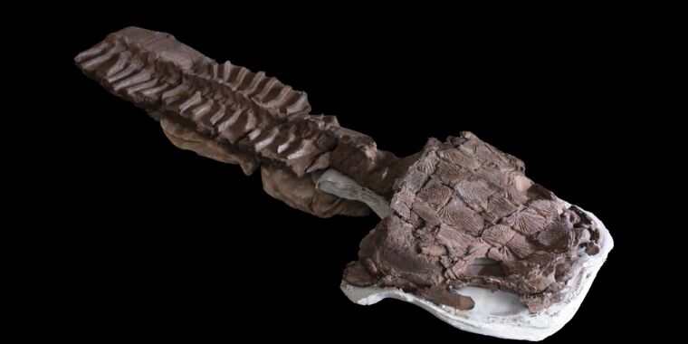
Gaiasia jennyae, a newly discovered freshwater apex predator with a body length reaching 4.5 meters, lurked in the swamps and lakes around 280 million years ago. Its wide, flattened head had powerful jaws full of huge fangs, ready to capture any prey unlucky enough to swim past.
The problem is, to the best of our knowledge, it shouldn’t have been that large, should have been extinct tens of millions of years before the time it apparently lived, and shouldn’t have been found in northern Namibia. “Gaiasia is the first really good look we have at an entirely different ecosystem we didn’t expect to find,” says Jason Pardo, a postdoctoral fellow at Field Museum of Natural History in Chicago. Pardo is co-author of a study on the Gaiasia jennyae discovery recently published in Nature.
Common ancestry
“Tetrapods were the animals that crawled out of the water around 380 million years ago, maybe a little earlier,” Pardo explains. These ancient creatures, also known as stem tetrapods, were the common ancestors of modern reptiles, amphibians, mammals, and birds. “Those animals lived up to what we call the end of Carboniferous, about 370–300 million years ago. Few made it through, and they lasted longer, but they mostly went extinct around 370 million ago,” he adds.
This is why the discovery of Gaiasia jennyae in the 280 million-year-old rocks of Namibia was so surprising. Not only wasn’t it extinct when the rocks it was found in were laid down, but it was dominating its ecosystem as an apex predator. By today’s standards, it was like stumbling upon a secluded island hosting animals that should have been dead for 70 million years, like a living, breathing T-rex.
“The skull of gaiasia we have found is about 67 centimeters long. We also have a front end of her upper body. We know she was at minimum 2.5 meters long, probably 3.5, 4.5 meters—big head and a long, salamander-like body,” says Pardo. He told Ars that gaiasia was a suction feeder: she opened her jaws under water, which created a vacuum that sucked her prey right in. But the large, interlocked fangs reveal that a powerful bite was also one of her weapons, probably used to hunt bigger animals. “We suspect gaiasia fed on bony fish, freshwater sharks, and maybe even other, smaller gaiasia,” says Pardo, suggesting it was a rather slow, ambush-based predator.
But considering where it was found, the fact that it had enough prey to ambush is perhaps even more of a shocker than the animal itself.
Location, location, location
“Continents were organized differently 270–280 million years ago,” says Pardo. Back then, one megacontinent called Pangea had already broken into two supercontinents. The northern supercontinent called Laurasia included parts of modern North America, Russia, and China. The southern supercontinent, the home of gaiasia, was called Gondwana, which consisted of today’s India, Africa, South America, Australia, and Antarctica. And Gondwana back then was pretty cold.
“Some researchers hypothesize that the entire continent was covered in glacial ice, much like we saw in North America and Europe during the ice ages 10,000 years ago,” says Pardo. “Others claim that it was more patchy—there were those patches where ice was not present,” he adds. Still, 280 million years ago, northern Namibia was around 60 degrees southern latitude—roughly where the northernmost reaches of Antarctica are today.
“Historically, we thought tetrapods [of that time] were living much like modern crocodiles. They were cold-blooded, and if you are cold-blooded the only way to get large and maintain activity would be to be in a very hot environment. We believed such animals couldn’t live in colder environments. Gaiasia shows that it is absolutely not the case,” Pardo claims. And this turned upside-down lots of what we knew about life on Earth back in gaiasia’s time.
Enlarge/ New research lends further credence to the “population crash” theory about Easter Island being just a myth.
Arian Zwegers/CC BY 2.0
For centuries, Western scholars have touted the fate of the native population on Easter Island (Rapa Nui) as a case study in the devastating cost of environmentally unsustainable living. The story goes that the people on the remote island chopped down all the trees to build massive stone statues, triggering a population collapse. Their numbers were further depleted when Europeans discovered the island and brought foreign diseases, among other factors. But an alternative narrative began to emerge in the 21st century that the earliest inhabitants actually lived quite sustainably until that point. A new paper published in the journal Science Advances offers another key piece of evidence in support of that alternative hypothesis.
As previously reported, Easter Island is famous for its giant monumental statues, called moai, built some 800 years ago and typically mounted on platforms called ahu. Scholars have puzzled over the moai on Easter Island for decades, pondering their cultural significance, as well as how a Stone Age culture managed to carve and transport statues weighing as much as 92 tons. The first Europeans arrived in the 17th century and found only a few thousand inhabitants on a tiny island (just 14 by 7 miles across) thousands of miles away from any other land. Since then, in order to explain the presence of so many moai, the assumption has been that the island was once home to tens of thousands of people.
But perhaps they didn’t need tens of thousands of people to accomplish that feat. Back in 2012, Carl Lipo of Binghamton University and Terry Hunt of the University of Arizona showed that you could transport a 10-foot, 5-ton moai a few hundred yards with just 18 people and three strong ropes by employing a rocking motion. In 2018, Lipo proposed an intriguing hypothesis for how the islanders placed red hats on top of some moai; those can weigh up to 13 tons. He suggested the inhabitants used ropes to roll the hats up a ramp. Lipo and his team later concluded (based on quantitative spatial modeling) that the islanders likely chose the statues’ locations based on the availability of fresh water sources, per a 2019 paper in PLOS One.
In 2020, Lipo and his team turned their attention to establishing a better chronology of human occupation of Rapa Nui. While it’s generally agreed that people arrived in Eastern Polynesia and on Rapa Nui sometime in the late 12th century or early 13th century, we don’t really know very much about the timing and tempo of events related to ahu construction and moai transport in particular. In his bestselling 2005 book Collapse, Jared Diamond offered the societal collapse of Easter Island (aka Rapa Nui), around 1600, as a cautionary tale. Diamond controversially argued that the destruction of the island’s ecological environment triggered a downward spiral of internal warfare, population decline, and cannibalism, resulting in an eventual breakdown of social and political structures.
Challenging a narrative
Lipo has long challenged that narrative, arguing as far back as 2007 against the “ecocide” theory. He and Hunt published a paper that year noting the lack of evidence of any warfare on Easter Island compared to other Polynesian islands. There are no known fortifications, and the obsidian tools found were clearly used for agriculture. Nor is there much evidence of violence among skeletal remains. He and Hunt concluded that the people of Rapa Nui continued to thrive well after 1600, which would warrant a rethinking of the popular narrative that the island was destitute when Europeans arrived in 1722.
For their 2020 study, the team applied a Bayesian model-based method to existing radiocarbon dates collected from prior excavations at 11 different sites with ahu. That work met with some mixed opinions from Lipo’s fellow archaeologists, with some suggesting that his team cherry-picked its radiocarbon dating—an allegation he dismissed at the time as “simply baloney and misinformed thinking.” They filtered their radiocarbon samples to just those they were confident related to human occupation and human-related events, meaning they analyzed a smaller subset of all the available ages—not an unusual strategy to eliminate bias due to issues with old carbon—and the results for colonization estimates were about the same as before.
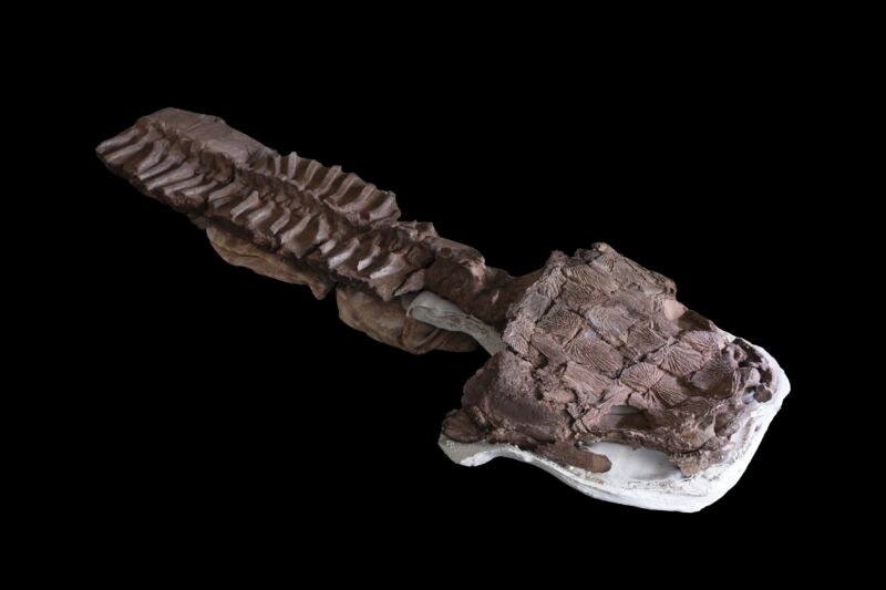
Enlarge/ Binghamton University’s Robert J. DiNapoli stands next to a rock garden on Rapa Nui, or Easter Island.
Robert J. DiNapoli
The model also integrated the order and position of the island’s distinctive architecture, as well as ethnohistoric accounts, thereby quantifying the onset of monument construction, the rate at which it occurred, and when it likely ended. This allowed the researchers to test Diamond’s “collapse” hypothesis by building a more precise timeline of when construction took place at each of the sites. The results demonstrated a lack of evidence for a pre-contact collapse and instead offered strong support for a new emerging model of resilient communities that continued their long-term traditions despite the impacts of European arrival.
Fresh evidence
Now Lipo is back with fresh findings in support of his alternative theory, having analyzed the landscape to identify all the agricultural areas on the island. “We really wanted to look at the evidence for whether the island could in fact support such a large number of people,” he said during a media briefing. “What we know about the pre-contact people living on the island is that they survived on a combination of marine resources—fishing accounted for about 50 percent of their diet—and growing crops,” particularly the sweet potato, as well as taro and yams.
He and his co-authors set out to determine how much food could be produced agriculturally, extrapolating from that the size of a sustainable population. The volcanic soil on Easter Island is highly weathered and thus poor in nutrients essential for plant growth: nitrogen, phosphorus and potassium primarily, but also calcium, magnesium, and sulfur. To increase yields, the natives initially cut down the island’s trees to get nutrients back into the soil.
When there were no more trees, they engaged in a practice called “lithic mulching,” a form of rock gardening in which broken rocks were added to the first 20 to 25 centimeters (about 8 to 10 inches) of soil. This added essential nutrients back into the soil. “We do it ourselves with non-organic fertilizer,” said Lipo. “Essentially we use machines to crush rock into tiny pieces, which is effective because it exposes a lot of surface area. The people in Rapa Nui are doing it by hand, literally breaking up rocks and sticking them in dirt.”
There had been only one 2013 study aimed at determining the island’s rock-garden capacity, which relied on near-infrared bands from satellite images. The authors of that study estimated that between 4.9 and 21.2 km2 of the island’s total area comprised rock gardens, although they acknowledged this was likely an inaccurate estimation.
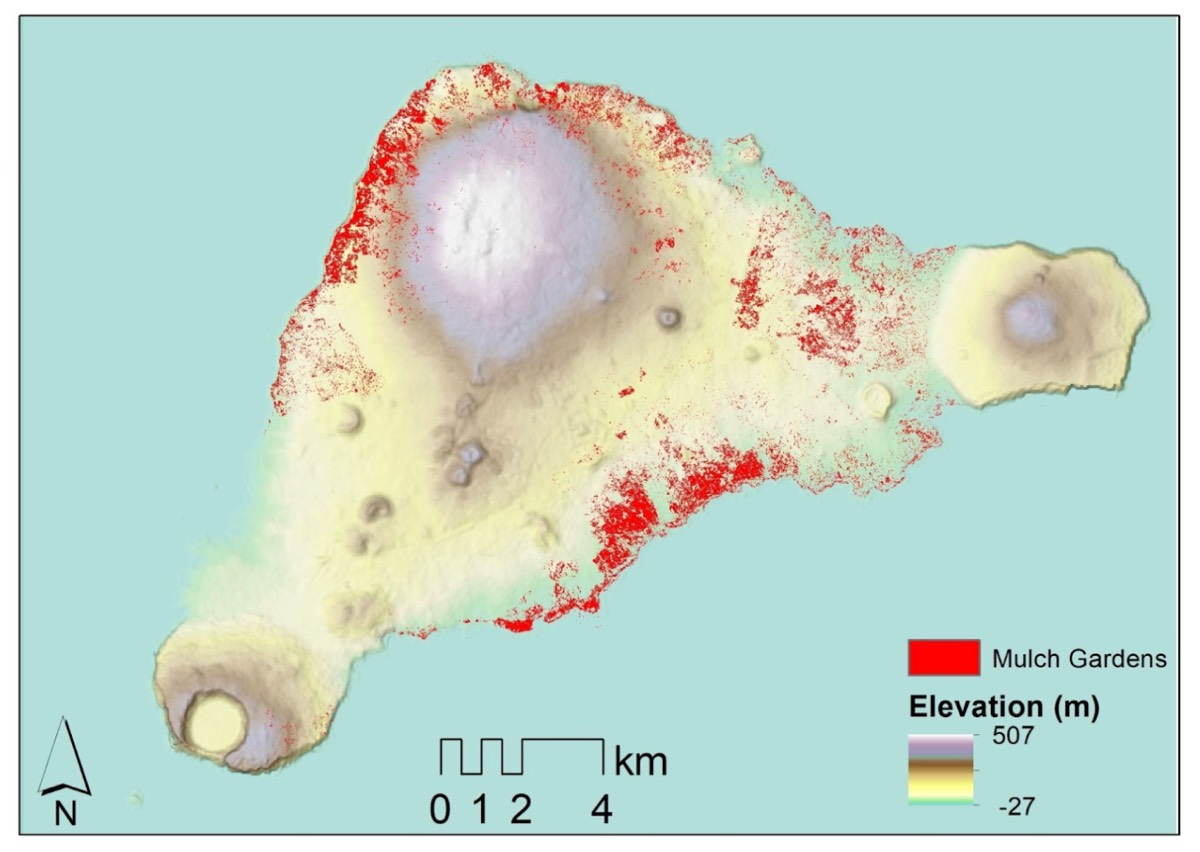
Enlarge/ A map of results from the analysis of rock gardens on Easter Island.
Carl Lipo
Lipo et al. examined satellite imagery data collected over the last five years, not just in the near-infrared, but also short-wave infrared (SWIR) and other visible spectra. SWIR is particularly sensitive to detecting water and nitrogen levels, making it easier to pinpoint areas where lithic mulching occurred. They trained machine-learning models on archaeological field identifications of rock garden features to analyze the SWIR data for a new estimation of capacity.
The result: Lipo et al. determined that the prevalence of rock gardening was about one-fifth of even the most conservative previous estimates of population size on Easter Island. They estimate that the island could support about 3,000 people—roughly the same number of inhabitants European explorers encountered when they arrived. “Previous studies had estimated that the island was fairly covered with mulch gardening, which led to estimates of up to 16,000 people,” said Lipo. “We’re saying that the island could never have supported 16,000 people; it didn’t have the productivity to do so. This pre-European collapse narrative simply has no basis in the archaeological record.”
“We don’t see demographic change decline in populations prior to Europeans’ arrival,” Lipo said. “All the [cumulative] evidence to date shows a continuous growth until some plateau is reached. It certainly was never an easy place to live, but people were able to figure out a means of doing so and lived within the boundaries of the capacity of the island up until European arrival.” So rather than being a cautionary tale, “Easter Island is a great case of how populations adapt to limited resources on a finite place, and do so sustainably.”
Binghamton University archaeologist Carl Lipo has shed light on some of the ancient mysteries of Easter Island (Rapa Nui) through his ongoing research. Credit: Binghamton University, State University of New York
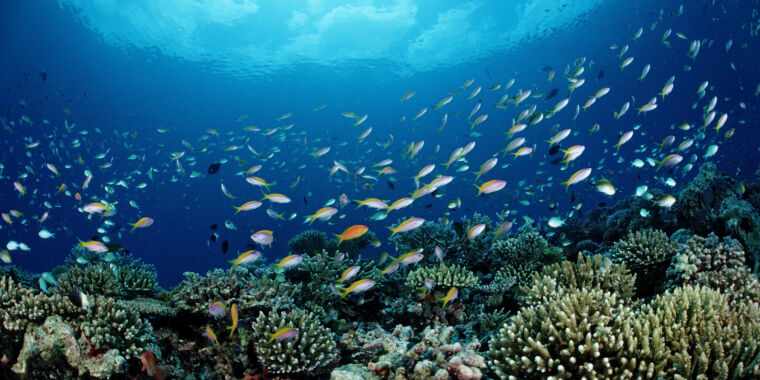
Coral reefs, some of the most stunningly beautiful marine ecosystems on Earth, are dying. Ninety percent of them will likely be gone by 2050 due to rising ocean temperatures and pollution. “But it’s not that when they are gone, they are gone forever. We can rebuild them,” said Dr. Timothy Lamont, a marine biologist working at Lancaster University.
Lamont’s team evaluated coral reef restoration efforts done through the MARS Coral Reef Restoration Program on the coast of Indonesia and found that planting corals on a network of sand-coated steel frames brought a completely dead reef back to life in just four years. It seems like we can fix something for once.
Growing up in rubble
The restored reef examined by Lamont’s team was damaged by blast fishing done 30–40 years ago. “People were using dynamite to blow up the reef. It kills all the fish, the fish float to the surface, and you can scoop them all up. Obviously, this is very damaging to the habitat and leaves behind loose rubble fields with lots of coral skeletons,” said Lamont.
Because this loose ruble is in constant motion, tumbling and rolling around, coral larvae don’t have enough time to grow before they get squashed. So the first step to bringing damaged reefs back to life was stabilizing the rubble. The people running the MARS program did this using Reef Stars, hexagonal steel structures coated with sand. “These structures are connected into networks and pinned to the seabed to reduce the movement of the rubble,” Lamont said.
Before the reef stars were placed on the seabed, though, the MARS team manually tied little corals around them. This was meant to speed up recovery compared to letting coral larvae settle on the steel structures naturally. Based on some key measures, it worked. But there are questions about whether those measures capture everything we need to know.
Artificial coral reefs
The metric Lamont’s team used to measure the success of the MARS program restoration was a carbonate budget, which describes an overall growth of the whole reef structure. According to Lamont, a healthy coral reef has a positive carbonate budget and produces roughly 20 kilograms of limestone per square meter per year. This is exactly what his team measured in restored sites on the Indonesian reef. But while the recovered reef had the same carbonate budget as a healthy one, the organisms contributing to this budget were different.
An untouched natural reef is a diverse mixture including massive, encrusting, and plating coral species like Isopora or Porites, which contribute roughly a third of the carbonate budget. Restored reefs were almost completely dominated by smaller, branching corals like Stylophora, Acropora, and Pocillopora, which are all fast-growing species initially tied onto reef stars. The question was whether the MARS program achieved its astounding four-year reef recovery time by sacrificing biodiversity and specifically choosing corals that grow faster.
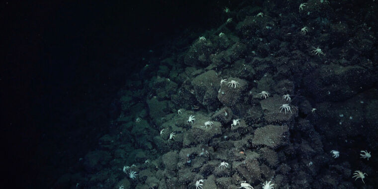
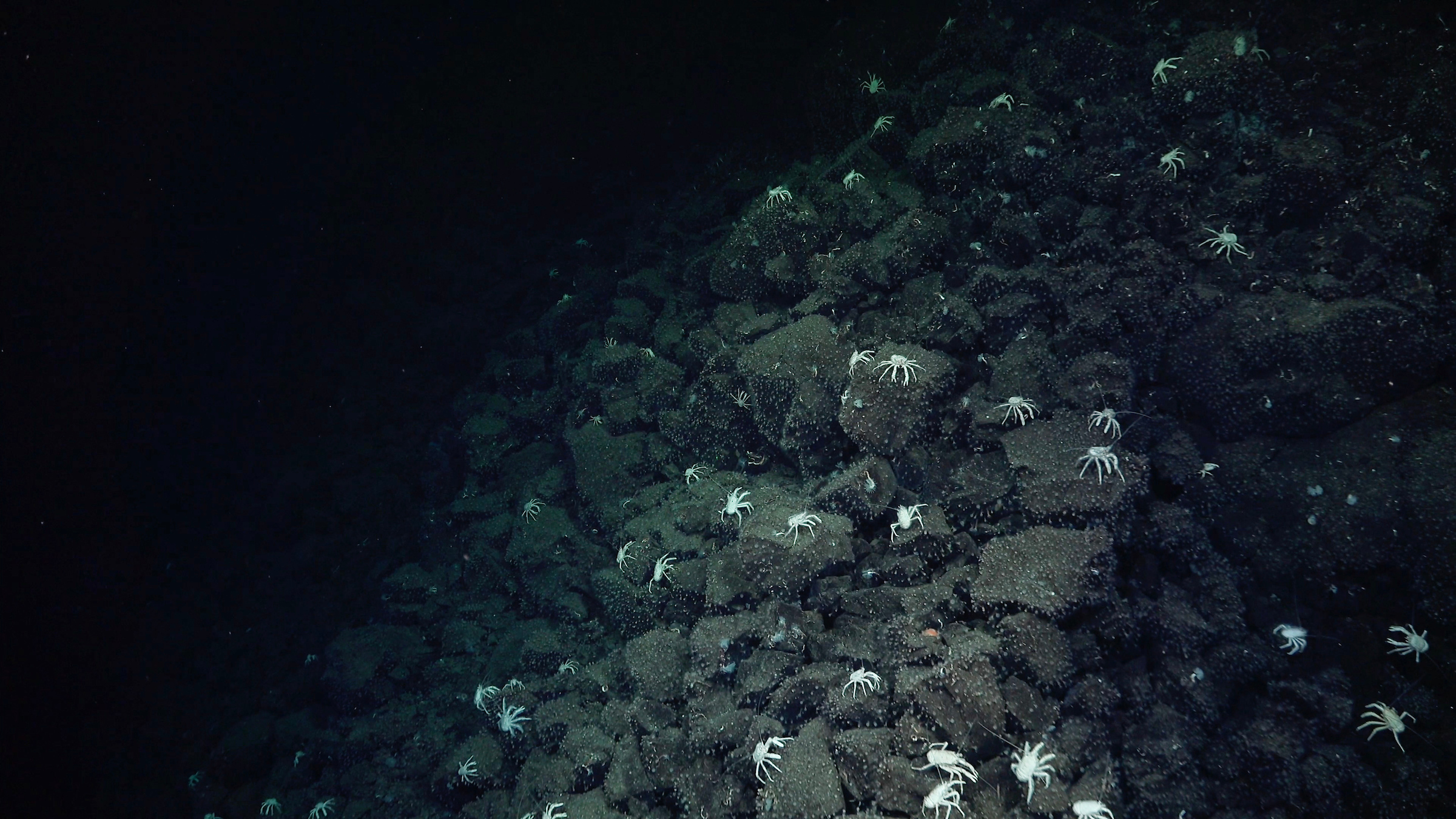
Enlarge/ “Leading us like breadcrumbs…” A trail of squat lobsters helped researchers locate previously unknown hydrothermal vents. The hydrothermal vents create chemosynthetic ecosystems, so in areas that are mostly barren of life, the appearance of larger animals can be an indicator of vents nearby.
Spectacular scenery, from lush rainforests to towering mountain ranges, dots the surface of our planet. But some of Earth’s most iconic landmarks––ones that may harbor clues to the origin of life on Earth and possibly elsewhere––lay hidden at the bottom of the ocean. Scientists recently found one such treasure in Ecuadorian waters: a submerged mini Yellowstone called Sendero del Cangrejo.
This hazy alien realm simmers in the deep sea in an area called the Western Galápagos Spreading Center––an underwater mountain range where tectonic plates are slowly moving away from each other. Magma wells up from Earth’s mantle here to create new oceanic crust in a process that created the Galápagos Islands and smaller underwater features, like hydrothermal vents. These vents, which pump heated, mineral-rich water into the ocean in billowing plumes, may offer clues to the origin of life on Earth. Studying Earth’s hydrothermal vents could also offer a gateway to finding life, or at least its building blocks, on other worlds.
The newly discovered Sendero del Cangrejo contains a chain of hydrothermal vents that spans nearly two football fields. It hosts hot springs and geyser chimneys that support an array of creatures, from giant, spaghetti-like tube worms to alabaster Galatheid crabs.
The crabs, also known as squat lobsters, helped guide researchers to Sendero del Cangrejo. Ecuadorian observers chose the site’s name, which translates to “Trail of the Crabs,” in their honor.
“It did feel like the squat lobsters were leading us like breadcrumbs, like we were Hansel and Gretel, to the actual vent site,” said Hayley Drennon, a senior research assistant at Columbia University’s Lamont-Doherty Earth Observatory, who participated in the expedition.
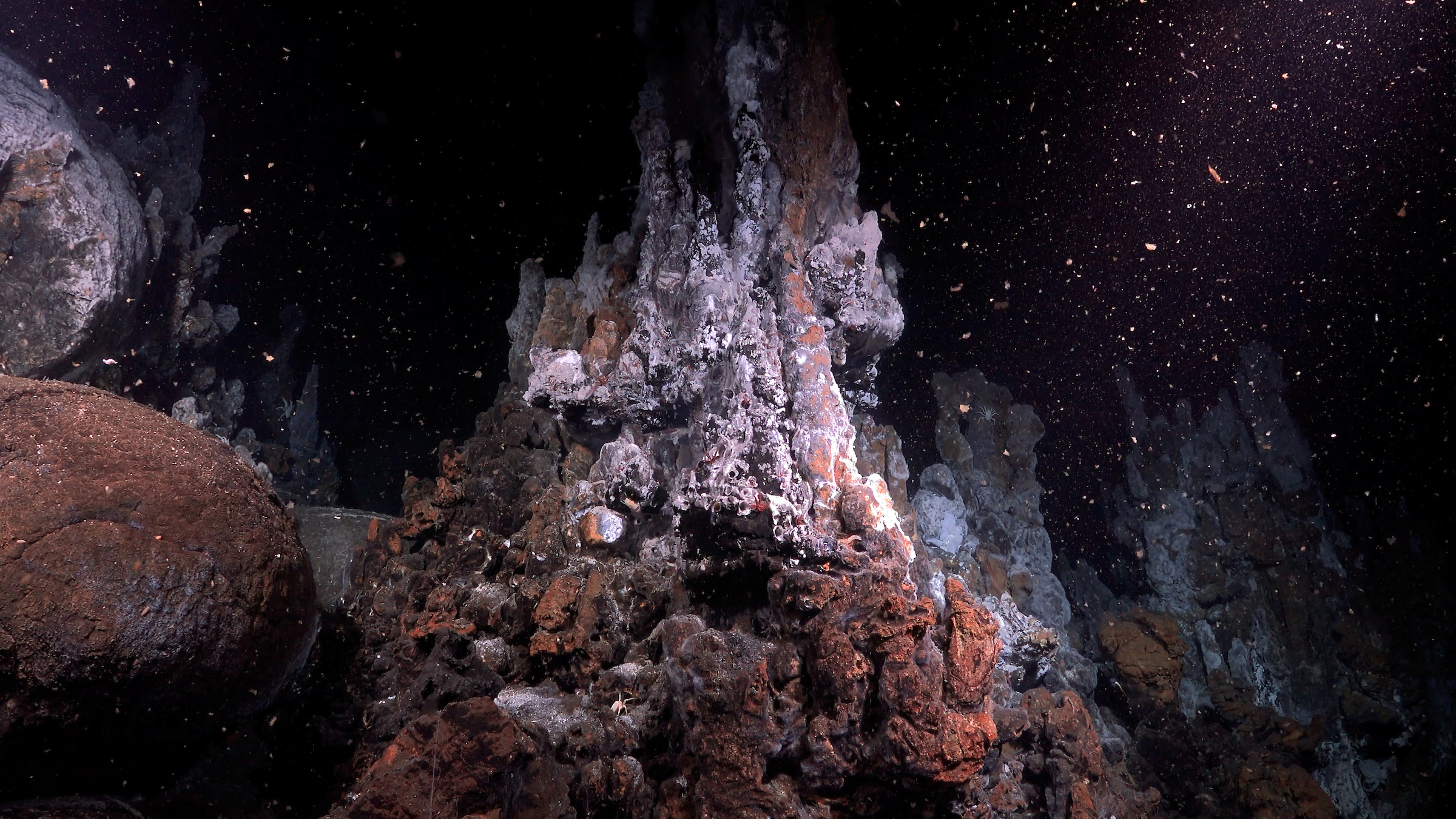
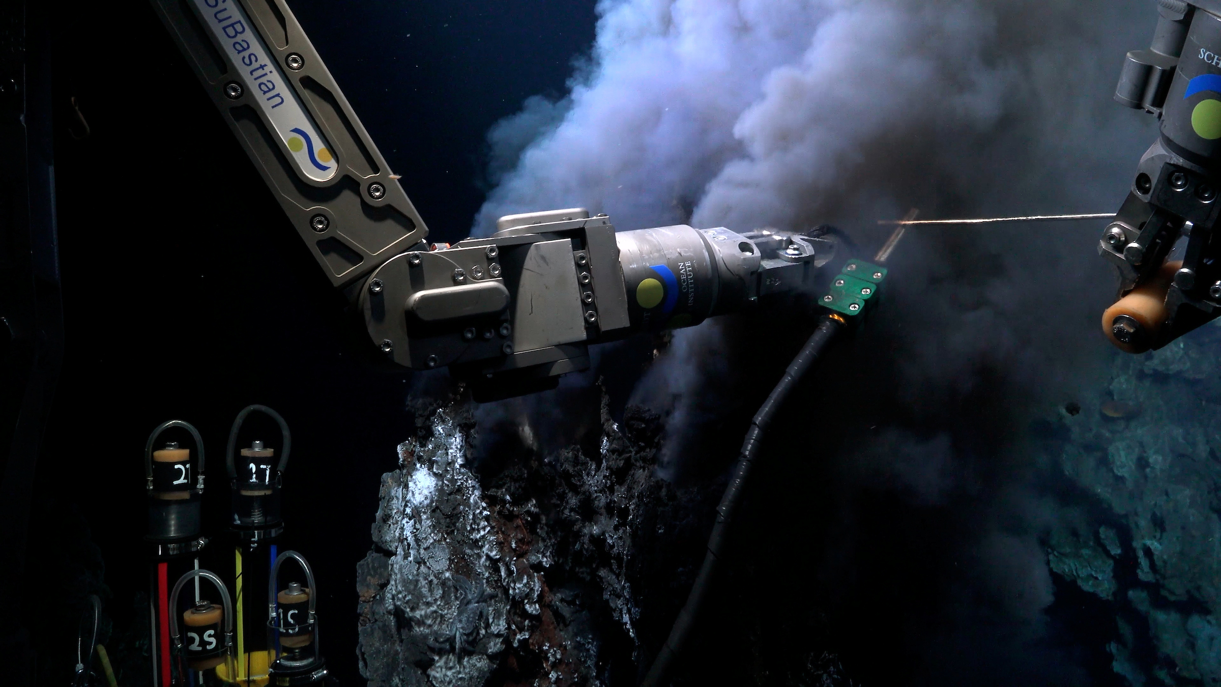
Enlarge/ The Iguanas Vent Field, where the team did some sampling.
The joint American and Ecuadorian research team set sail aboard the Schmidt Ocean Institute’s Falkor (too) research vessel in mid-August in search of new hydrothermal vents. They did some mapping and sampling on the way to their target location, about 300 miles off the west coast of the Galápagos.
The team used a ‘Tow-Yo’ technique to gather and transmit real-time data to the crew aboard the ship. “We lowered sensors attached to a long wire to the seafloor, and then towed the wire up and down like a yo-yo,” explained Roxanne Beinart, an associate professor at the University of Rhode Island and the expedition’s chief scientist. “This process allowed us to monitor changes in temperature, water clarity, and chemical composition to help pinpoint potential hydrothermal vent locations.”
When they reached a region that seemed promising, they deployed the remotely operated vehicle SuBastian for a better look. Less than 24 hours later, the team began seeing more and more Galatheid crabs, which they followed until they found the vents.
The crabs were particularly useful guides since the vent fluids there are clear, unlike “black smokers” that create easy-to-see plumes. SuBastian explored the area for about 43 hours straight in the robot’s longest dive to date.
But the true discovery process spanned decades. Researchers have known for nearly 20 years that the area was likely home to hydrothermal activity thanks to chemical signals measured in 2005. About a decade later, teams ventured out again and collected animal samples. Now, due to the Schmidt Ocean Institute’s recent expedition, scientists have the most comprehensive data set ever for this location. It includes chemical, geological, and biological data, along with the first high-temperature water samples.
“It’s not uncommon for an actual discovery like this to take decades,” said Jill McDermott, an associate professor at Lehigh University and the expedition’s co-chief scientist. “The ocean is a big place, and the locations are very remote, so it takes a lot of time and logistics to get out to them.” The team will continue their research onshore to help us understand how hydrothermal vents influence our planet.
Genesis from hell?
Sendero del Cangrejo may compare to a small-scale Yellowstone in some ways, but it’s no tourist destination. It’s pitch-black since sunlight can’t reach the deep ocean floor. The crushing weight of a mile of water presses down from overhead. And the vents are hot and toxic. Some of them clocked in at 290º C (550º F)—nearly hot enough to melt lead.
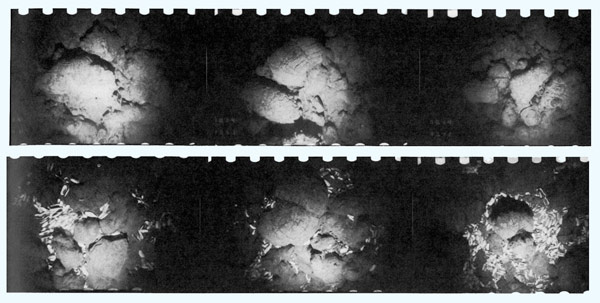
Before scientists discovered hydrothermal vents in 1977, they assumed such extreme conditions would preclude the possibility of life. Yet that trailblazing team saw multiple species thriving, including white clams that guided them to the vents the same way the Galatheid crabs led the modern researchers to Sendero del Cangrejo.
A series of seafloor photos shows the sudden appearance of live white clams that led scientists to find hydrothermal vents for the first time.
Before the 1977 find, no one knew life could survive in such a hostile place. Now, scientists know there are microbes called thermophiles that can only live in high temperatures (up to about 120º C, or 250º F).
Bacteria that surround hydrothermal vents don’t eat other organisms or create energy from sunlight like plants do. Instead, they produce energy using chemicals like methane or hydrogen sulfide that emanate from the vents. This process, called chemosynthesis, was first identified through the characterization of organisms discovered at these vents. Chemosynthetic bacteria are the backbone of hydrothermal vent ecosystems, serving as a nutrition source for higher organisms.
Some researchers suggest life on Earth may have originated near hydrothermal vents due to their unique chemical and energy-rich conditions. While the proposal remains unproven, the discovery of chemosynthesis opened our eyes to new places that could host life.
The possibility of chemosynthetic creatures diminishes the significance of so-called habitable zones around stars, which describe the orbital distances between which surface water can remain liquid on a planet or moon. The habitable zone in our own Solar System extends from about Venus’ orbit out nearly to Mars’.
NASA’s Europa Clipper mission is set to launch late next year to determine whether there are places below the surface of Jupiter’s icy moon, Europa, that could support life. It’s a lot colder out there, well beyond our Solar System’s habitable zone, but scientists think Europa is internally heated. It experiences strong tidal forces from Jupiter’s gravity, which could create hydrothermal activity on the moon’s ocean floor.
Several other moons in our Solar System also host subsurface oceans and experience the same tidal heating that could potentially create habitable conditions. By exploring Earth’s hydrothermal vents, scientists could learn more about what to look for in similar environments elsewhere in our Solar System.
“The Ocean’s Multivitamin”
While hydrothermal vents are relatively new to science, they’re certainly not new to our planet. “Vents have been active since Earth’s oceans first formed,” McDermott said. “They’ve been present in our oceans for as long as we’ve had them, so about 3 billion years.”
During that time, they’ve likely transformed our planet’s chemistry and geology by cycling chemicals and minerals from Earth’s crust throughout the ocean.
“All living things on Earth need minerals and elements that they get from the crust,” said Peter Girguis, a professor at Harvard University, who participated in the expedition. “It’s no exaggeration to say that all life on earth is inextricably tied to the rocks upon which we live and the geological processes occurring deep inside the planet…it’s like the ocean’s multivitamin.”
But the full extent of the impact hydrothermal vents have on the planet remains unknown. In the nearly 50 years since hydrothermal vents were first discovered, scientists have uncovered hundreds more spread around the globe. Yet no one knows how many remain unidentified; there are likely thousands more vents hidden in the deep. Detailed studies, like those the expedition scientists are continuing onshore, could help us understand how hydrothermal activity influences the ocean.
Enlarge/ ROV SuBastian takes water and chemical samples from a black smoker hydrothermal vent in the Iguanas Vent Field, Galapagos Islands.
The team’s immediate observations offer a good starting point for their continued scientific sleuthing.
“I actually expected to find denser animal populations in some places,” Beinart said.
McDermott thinks that could be linked to the composition of the vent fluids. “Several of the vents were clear—not very particle-rich,” she said. “They’re probably lower in minerals, but we’re not sure why.” Now, the team will measure different metal levels in water samples from the vent fluids to figure out why they’re low in minerals and whether that has influenced the animals the vents host.
Researchers are learning more about hydrothermal vents every day, but many mysteries remain, such as the eventual influence ocean acidification could have on vents. As they seek answers, they’re sure to find more questions and open up new avenues of scientific exploration.
Ashley writes about space as a contractor for NASA’s Goddard Space Flight Center by day and freelances as an environmental writer. She holds a master’s degree in space studies from the University of North Dakota and is finishing a master’s in science writing through The Johns Hopkins University. She writes most of her articles with one of her toddlers on her lap.


