Antarctica is starting to look a lot like Greenland—and that isn’t good
Global warming is awakening sleeping giants of ice at the South Pole.
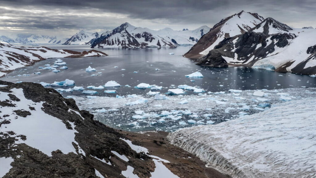
A view of the Shoesmith Glacier on Horseshoe Island on Feb. 21. Credit: Sebnem Coskun/Anadolu via Getty Images
As recently as the 1990s, when the Greenland Ice Sheet and the rest of the Arctic region were measurably thawing under the climatic blowtorch of human-caused global warming, most of Antarctica’s vast ice cap still seemed securely frozen.
But not anymore. Physics is physics. As the planet heats up, more ice will melt at both poles, and recent research shows that Antarctica’s ice caps, glaciers, and floating ice shelves, as well as its sea ice, are just as vulnerable to warming as the Arctic.
Both satellite data and field observations in Antarctica reveal alarming signs of a Greenland-like meltdown, with increased surface melting of the ice fields, faster-moving glaciers, and dwindling sea ice. Some scientists are sounding the alarm, warning that the rapid “Greenlandification” of Antarctica will have serious consequences, including an accelerated rise in sea levels and significant shifts in rainfall and drought patterns.
The Antarctic ice sheet covers about 5.4 million square miles, an area larger than Europe. On average, it is more than 1 mile thick and holds 61 percent of all the fresh water on Earth, enough to raise the global average sea level by about 190 feet if it all melts. The smaller, western portion of the ice sheet is especially vulnerable, with enough ice to raise sea level more than 10 feet.
Thirty years ago, undergraduate students were told that the Antarctic ice sheets were going to be stable and that they weren’t going to melt much, said Ruth Mottram, an ice researcher with the Danish Meteorological Institute and lead author of a new paper in Nature Geoscience that examined the accelerating ice melt and other similarities between changes in northern and southern polar regions.
“We thought it was just going to take ages for any kind of climate impacts to be seen in Antarctica. And that’s really not true,” said Mottram, adding that some of the earliest warnings came from scientists who saw collapsing ice shelves, retreating glaciers, and increased surface melting in satellite data.
One of the early warning signs was the rapid collapse of an ice shelf along the narrow Antarctic Peninsula, which extends northward toward the tip of South America, said Helen Amanda Fricker, a geophysics professor with the Scripps Institute of Oceanography Polar Center at the University of California, San Diego.
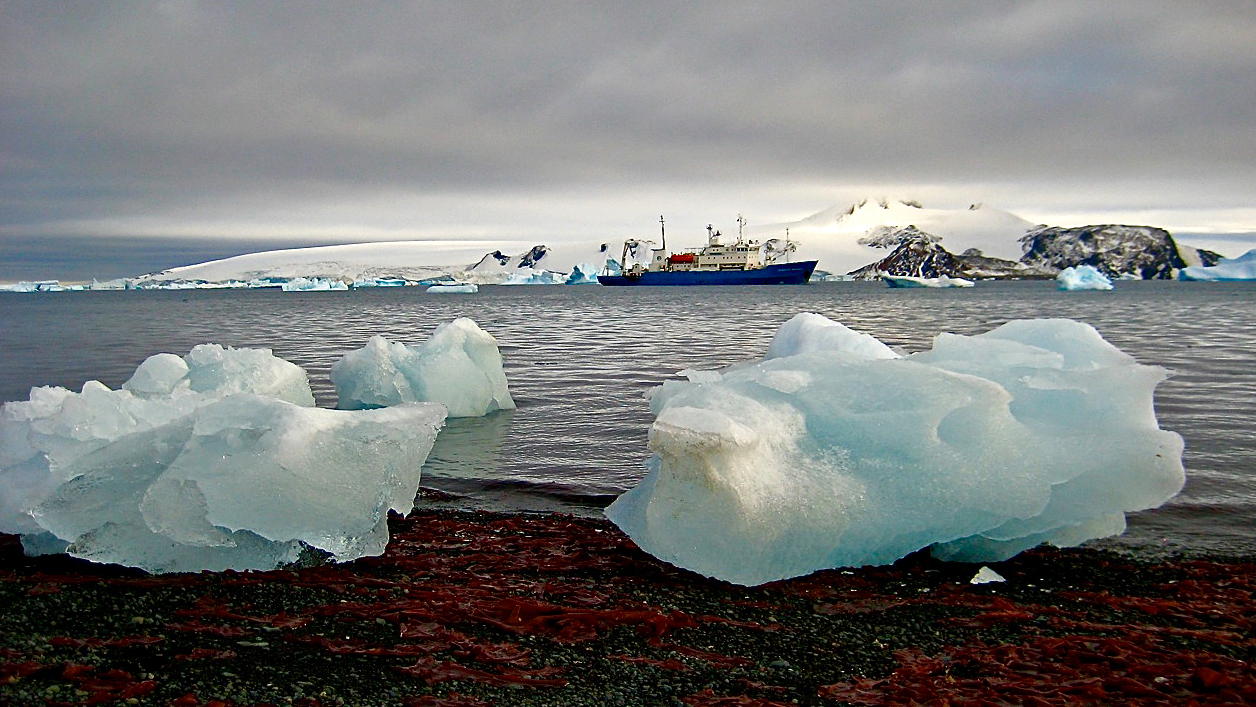
Stranded remnants of sea ice along the Antarctic Peninsula are a reminder that much of the ice on the frozen continent around the South Pole is just as vulnerable to global warming as Arctic ice, where a long-term meltdown is well underway.
Credit: Bob Berwyn/Inside Climate News
Stranded remnants of sea ice along the Antarctic Peninsula are a reminder that much of the ice on the frozen continent around the South Pole is just as vulnerable to global warming as Arctic ice, where a long-term meltdown is well underway. Credit: Bob Berwyn/Inside Climate News
After a string of record-warm summers riddled the floating Rhode Island-sized slab of ice with cracks and meltwater ponds, it crumbled almost overnight. The thick, ancient ice dam was gone, and the seven major outlet glaciers behind it accelerated toward the ocean, raising sea levels as their ice melted.
“The Larsen B ice shelf collapse in 2002 was a staggering event in our community,” said Fricker, who was not an author of the new paper. “We just couldn’t believe the pace at which it happened, within six weeks. Basically, the ice shelves are there and then, boom, boom, boom, a series of melt streams and melt ponds. And then the whole thing collapsed, smattered into smithereens.”
Glaciologists never thought that events would happen that quickly in Antarctica, she said.
Same physics, same changes
Fricker said glaciologists thought of changes in Antarctica on millennial timescales, but the ice shelf collapse showed that extreme warming can lead to much more rapid change.
Current research focuses on the edges of Antarctica, where floating sea ice and relatively narrow outlet glaciers slow the flow of the ice cap toward the sea. She described the Antarctic Ice Sheet as a giant ice reservoir contained by a series of dams.
“If humans had built those containment structures,” she said, “we would think that they weren’t very adequate. We are relying on those dams to hold back all of that ice, but the dams are weakening all around Antarctica and releasing more ice into the ocean.”
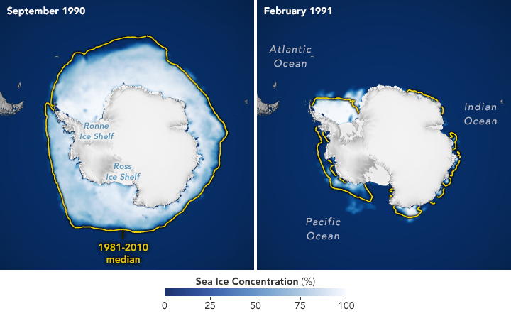
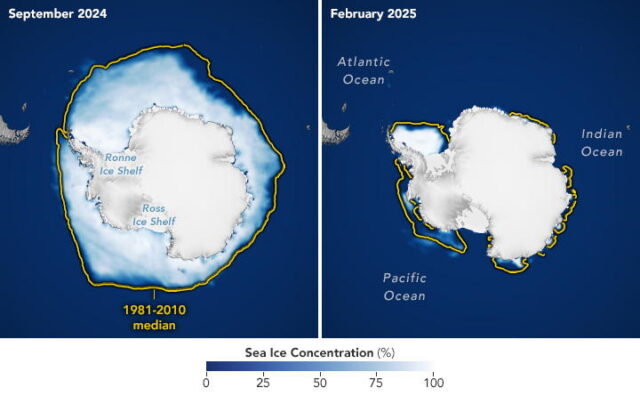
A comparison of the average concentration of Antarctic sea ice.
Credit: NASA Earth Observatory
A comparison of the average concentration of Antarctic sea ice. Credit: NASA Earth Observatory
Credit: NASA Earth Observatory
The amount of ice that’s entered the ocean has increased fourfold since the 1990s, and she said, “We’re on the cusp of it becoming a really big number… because at some point, there’s no stopping it anymore.”
The Antarctic Ice Sheet is often divided into three sectors: the East Antarctic Ice Sheet, the largest and thickest; the West Antarctic Ice Sheet; and the Antarctic Peninsula, which is deemed the most vulnerable to thawing and melting.
Mottram, the new paper’s lead author, said a 2022 heatwave that penetrated to the coldest interior part of the East Antarctic Ice Sheet may be another sign that the continent is not as isolated from the rest of the global climate system as once thought. The extraordinary 2022 heatwave was driven by an atmospheric river, or a concentrated stream of moisture-laden air. Ongoing research “shows that there’s been an increase in the number of atmospheric rivers and an increase in their intensity,” she said.
Antarctica is also encircled by a powerful circumpolar ocean current that has prevented the Southern Ocean from warming as quickly as other ocean regions. But recent climate models and observations show the buffer is breaking down and that relatively warmer waters are starting to reach the base of the ice shelves, she said.
New maps detailing winds in the region show that “swirls of air from higher latitudes are dragging in all the time, so it’s not nearly as isolated as we were always told when we were students,” she said.
Ice researcher Eric Rignot, an Earth system science professor at the University of California, Irvine, who did not contribute to the new paper, said via email that recent research on Antarctica’s floating ice shelves emphasizes the importance of how the oceans and ice interact, a process that wasn’t studied very closely in early Greenland research. And Greenland shows what will happen to Antarctic glaciers in a warmer climate with more surface melt and more intense ice-ocean interactions, he added.
“We learn from both but stating that one is becoming the other is an oversimplification,” he said. “There is no new physics in Greenland that does not apply to Antarctica and vice versa.”
Rignot said the analogy between the two regions also partly breaks down because Greenland is warming up at two to three times the global average, “which has triggered a slowing of the jet stream,” with bigger wobbles and “weird weather patterns” in the Northern Hemisphere.
Antarctica is warming slightly less than the global average rate, according to a 2025 study, and the Southern Hemisphere jet stream is strengthening and tightening toward the South Pole, “behaving completely opposite,” he said.
Mottram said her new paper aims to help people understand that Antarctica is not as remote or isolated as often portrayed, and that what happens there will affect the rest of the global climate system.
“It’s not just this place far away that nobody goes to and nobody understands,” she said. “We actually understand quite a lot of what’s going on there. And so I also hope that it drives more urgency to decarbonize, because it’s very clear that the only way we’re going to get out of this problem is bringing our greenhouse gases down as much as possible, as soon as possible.”
This story originally appeared on Inside Climate News.
![]()
Antarctica is starting to look a lot like Greenland—and that isn’t good Read More »


