The results: The team found traces of wild grasses and legumes, fruits or berries, green vegetables, and roots and tubers native to the broader region. Shards recovered from sites in the Don River basin showed these people used the seeds of wild legumes (possibly clover) and grasses, as well as showing some evidence of bran and barley. By contrast, shards from the Upper Volga and Dnieper-Dvina region contained more traces of guelder rose berries and other fleshy fruits and smaller-seeded Amaranthaceae plants.
Shards from the Baltic region showed higher traces of freshwater fish, with some regions also including berries, sea beetroot, flowering rush, beets, and sea club-rush tubers. There were also traces of dairy products in shards from a site in Denmark, likely obtained from nearby farming communities.
For the cooking experiments, the authors explored different potential food mixtures focusing on two main plant species: guelder rose berries and species related to the Amaranthaceae family (beet, goosefoot, and saltbush specifically). The berries were gathered in the fall from the south of England and frozen right afterward. They boiled the berries with water in replica pottery vessels, combining some batches with freshwater fish like carp, and also varying the distance of the vessels from the open flames and active embers. They then sampled the cooking residues and compared those results to the samples taken from the prehistoric vessels.
“Our results show that there was a general tendency towards combining specific foods into distinct preparations and in particular regions,” the authors concluded, such as combining Viburnum berries with freshwater fish in the Upper Volga and Baltic regions. Fish accompanied by wild grasses and legumes were preferred in the Don River Basin, while other sites preferred their fish with green vegetables. So “hunter-gatherer-fishers were not living on fish alone,” the authors wrote. “They were actively processing and consuming a wide variety of plants.”
The revised age may help make sense of 2-million-year-old stone tools elsewhere in China.
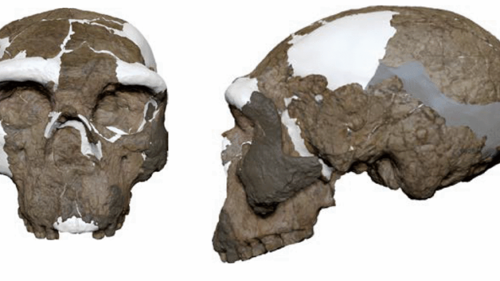
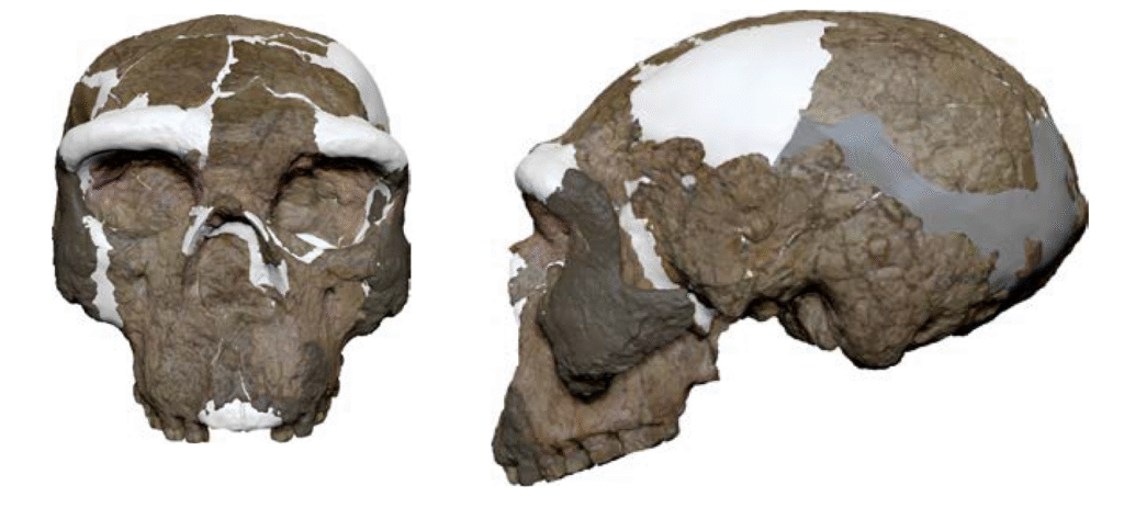
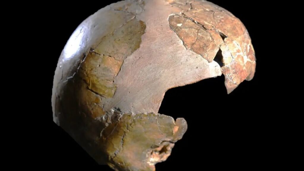
Two skulls from Yunxian, in northern China, aren’t ancestors of Denisovans after all; they’re actually the oldest known Homo erectus fossils in eastern Asia.
A recent study has re-dated the skulls to about 1.77 million years old, which makes them the oldest hominin remains found so far in East Asia. Their age means that Homo erectus (an extinct common ancestor of our species, Neanderthals, and Denisovans) must have spread across the continent much earlier and much faster than we’d previously given them credit for. It also sheds new light on who was making stone tools at some even older archaeological sites in China.
Homo erectus spread like wildfire
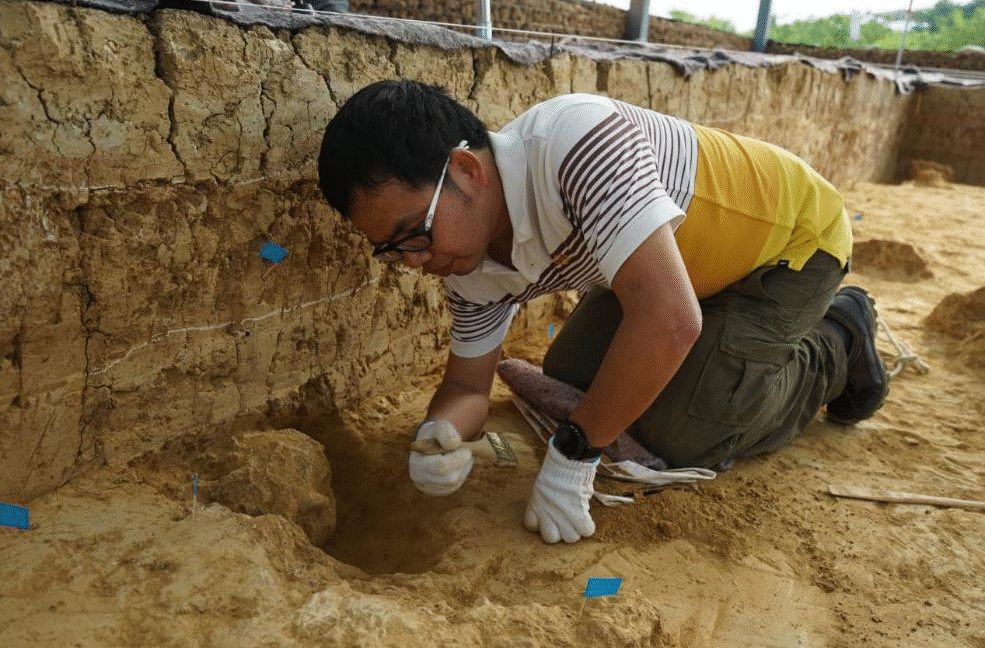
Yunxian is an important—and occasionally contentious—archaeological site on the banks of central China’s Han River. Along with hundreds of stone tools and animal bones, the layers of river sediment have yielded three nearly complete hominin skulls (only two of which have been described in a publication so far). Shantou University paleoanthropologist Hua Tu and his colleagues measured the ratio of two isotopes, aluminum-26 and beryllium-10, in grains of quartz from the sediment layer that once held the skulls. The results suggest that Homo erectus lived and died along the Han River 1.77 million years ago. That’s just 130,000 years after the species first appeared in Africa.
(Side note: This river has been depositing layers of silt and gravel on the same terraces for at least 2 million years, and that’s just extremely cool.)
The revised date suggests that Homo erectus spread across Asia much more quickly than anthropologists had realized. So far, the oldest hominin bones found anywhere outside Africa are five skulls, along with hundreds of other bones, from Dmanisi Cave in Georgia. The Dmanisi bones are between 1.85 million and 1.77 million years old, and they (probably—more on that below) also belong to Homo erectus.
Until recently, the next-oldest Homo erectus fossils outside Africa were the 1.63-million-year-old fossils from another Chinese site, Gongwangling, a short distance north of Yunxian. (That’s not counting a couple of teeth from a site in southern China with an age that is a little less certain.) Those dates had suggested Homo erectus seemed to have taken a leisurely 140,000 years to spread east into Asia. But it now looks like hominins were living in Georgia and central China at about the same time, which means they spread out very fast, started earlier than we knew, or both.
The Homo longi and short of it
All of this means that the Yunxian skulls are probably not—as a September 2025 study claimed—close ancestors of the enigmatic Denisovans. The authors of that paper had digitally reconstructed one of the skulls and concluded that it looked a lot like a 146,000-year-old skull from Harbin, China (which a recent DNA study identified as a Denisovan, also known as Homo longi).
The researchers had argued that the original owners of the Yunxian skulls had lived not long after the Denisovan/Homo longi branch of the hominin family tree split off from ours—in other words, that the Yunxian skulls weren’t mere Homo erectus but early Homo longi, close cousins of our own species. Using the original paleomagnetic dates for the Yunxian skulls, that study’s authors drew up a hominin family tree in which our species and Denisovans are more closely related to each other than either is to Neanderthals—one in which the branching happened much earlier than DNA evidence suggests.
There were many issues with those arguments, but the revised age for the Yunxian skulls sounds like a death knell for them. “1.77 million years is just too old to be a credible connection to the Denisovan group, which DNA tells us got started after around 700,000 years ago,” University of Wisconsin paleoanthropologist John Hawks, who was not involved in the study, told Ars in an email.
But the most interesting thing about these skulls being 1.77 million years old is that the date provides a reference point for understanding even older sites in China—sites that may suggest that Homo erectus wasn’t even the first hominin to make it this far.
Stone tools collected from Shangchen, China.
Credit: Prof. Zhaoyu Zhu
Stone tools collected from Shangchen, China. Credit: Prof. Zhaoyu Zhu
Out of Africa: The prequel
Homo erectus first shows up in the fossil record around 1.9 million years ago in Africa, where it’s sometimes also called Homo ergaster because paleoanthropologists seem to enjoy naming things and then arguing about those names for several decades. A few hundred thousand years later, Homo erectus showed up everywhere: from South Africa northward to the Levant and from Dmanisi Cave in Georgia eastward to the islands of Indonesia.
We typically think of Homo erectus as the first of our hominin ancestors to expand beyond Africa, along routes that our own species would retread 1.5 million years later. More to the point, many paleoanthropologists think of them as the first hominin that could have adapted to so many different environments, each with its own challenges, along the way.
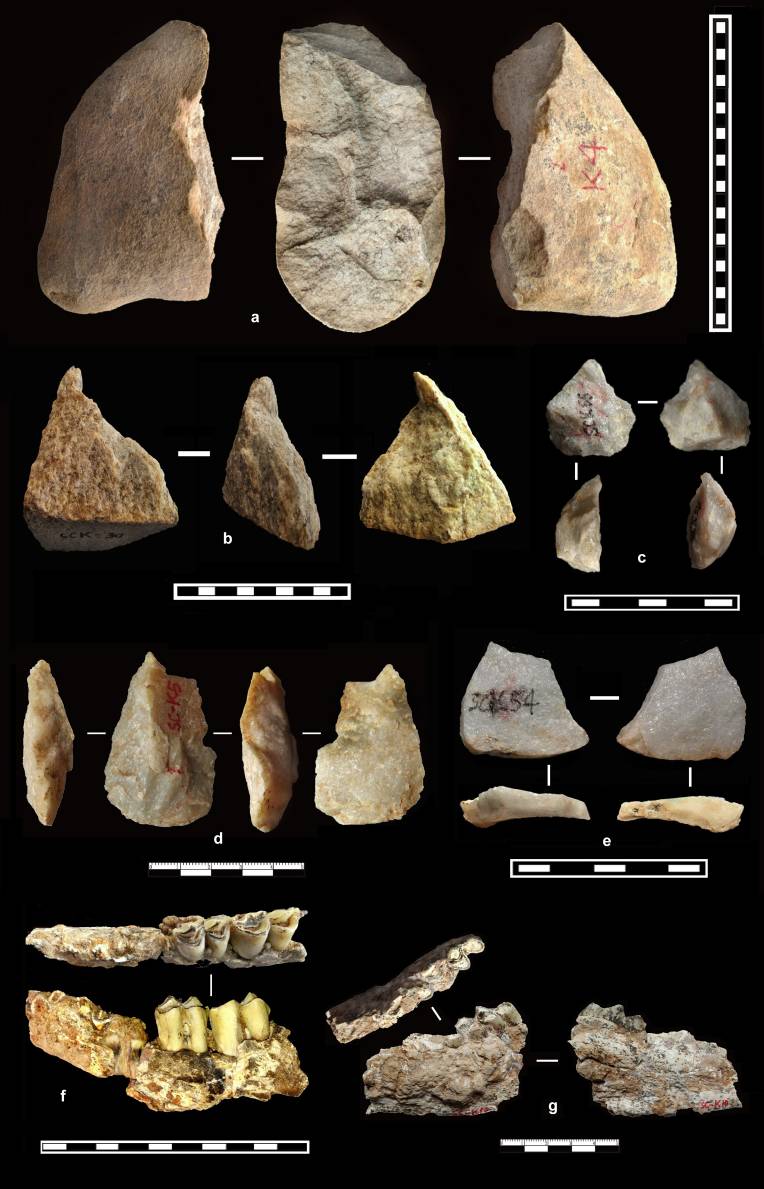
But we may need to give earlier members of our genus, like Homo habilis,a little more credit because stone tools from two other sites in China seem to be older than Homo erectus. At Shangchen, a site on the southern edge of China’s Loess Plateau, archaeologists unearthed stone tools from a 2.1-million-year-old layer of sediment. And at the Xihoudu site in northern China, stone tools date to 2.43 million years ago.
“If you have a site in China that’s 2.43 million years, and the origin of Homo erectus is 1.9 million years ago, either you need to push the origin of Homo erectus back to 2.5 or 2.6 million years or we need to accept that we need to be looking at other hominins that may have actually moved out of Africa,” University of Hawai’i at Manoa paleoanthropologist Christopher Bae, a coauthor of the new study, told Ars.
So who made those 2-million-year-old tools?
Archaeologists have unearthed stone tools but no hominin fossils at both sites, making it difficult to say for sure who the toolmakers were. But if they weren’t Homo erectus, the next most likely suspects would be older members of our genus, like Homo habilis or Homo rudolfensis. That would mean hominin expansion “out of Africa” actually happened several times during the history of our genus: once with early Homo, again with Homo erectus, and yet again with our species.
“There could have been an earlier wave that died out or interbred, so there’s all kinds of possibilities open there,” Purdue University paleoanthropologist Darryl Granger, also a coauthor of the recent study, told Ars.
In fact, there’s some debate about whether the Dmanisi fossils actually belonged to Homo erectus proper. One thing the two dueling reconstructions of the Yunxian skulls agree on is that those hominins had flattish faces, more like ours—and like the 1.63-million-year-old Homo erectus skull from Gongwangling. But the Dmanisi hominins’ lower faces project dramatically forward, like those of older hominins.
Some paleoanthropologists classify the Dmanisi fossils as their own species, but others argue they’re more like early members of our genus, such as Homo habilis or Homo rudolfensis. Those earlier hominins may have been more capable of migrating and adapting than we’ve realized.
It’s still very clear, from both fossil and genetic evidence, that our species evolved in Africa and spread from there to the rest of the world. But it’s also increasingly clear that there were several other species of hominins in other places, doing other things, at least off and on, for a very long time before we showed up. Yunxian, and its revised age, could help anthropologists better understand part of that story.
“Actually being able to anchor the Homo erectus sites with firm, solid dates helps us try to reconfigure this model,” said Bae. “This is where Yunxian really plays a major role in this. Now that we’ve got older dates to anchor the Yunxian Homo erectus fossils, I think we can really bring in this discussion with Xihoudu and Shangchen.”
Time to dig deeper
The answers may still lie buried—maybe just a few meters below the fossil skulls and stone tools at sites like Yunxian and Gongwangling, in older sediment layers. Archaeologists may not have seen a reason to explore these, since no one lived in China before 1.7 million years ago. The age of the Yunxian skulls, along with the even older stone tools at Shangchen and Xihoudu, may warrant deeper digging.
“People haven’t been looking for artifacts and fossils in two-plus million-year-old sediments in these locations in China,” said Granger. “I can think of places that I would like to go back and look if I had more time and money.”
At other sites, researchers have already unearthed fossil animal bones from the same age range as China’s oldest stone tools, but paleoanthropologists haven’t double-checked whether any of those bones might belong to early hominins rather than other mammals. Bae said, “It’s just that they haven’t been receiving any attention, or not enough attention.”
Science Advances, 2026. DOI: 10.1126/sciadv.ady2270 About DOIs).
Kiona is a freelance science journalist and resident archaeology nerd at Ars Technica.
The world’s oldest art has an unintentional story to tell about human exploration.
These 17,000-year-old hand stencils from Liang Jarie Maros, in another area of Sulawesi, bear a striking resemblance to the much older ones in Liang Metanduno. Credit: OKtaviana et al. 2026
The world’s oldest surviving rock art is a faded outline of a hand on an Indonesian cave wall, left 67,800 years ago.
On a tiny island just off the coast of Sulawesi (a much larger island in Indonesia), a cave wall bears the stenciled outline of a person’s hand—and it’s at least 67,800 years old, according to a recent study. The hand stencil is now the world’s oldest work of art (at least until archaeologists find something even older), as well as the oldest evidence of our species on any of the islands that stretch between continental Asia and Australia.
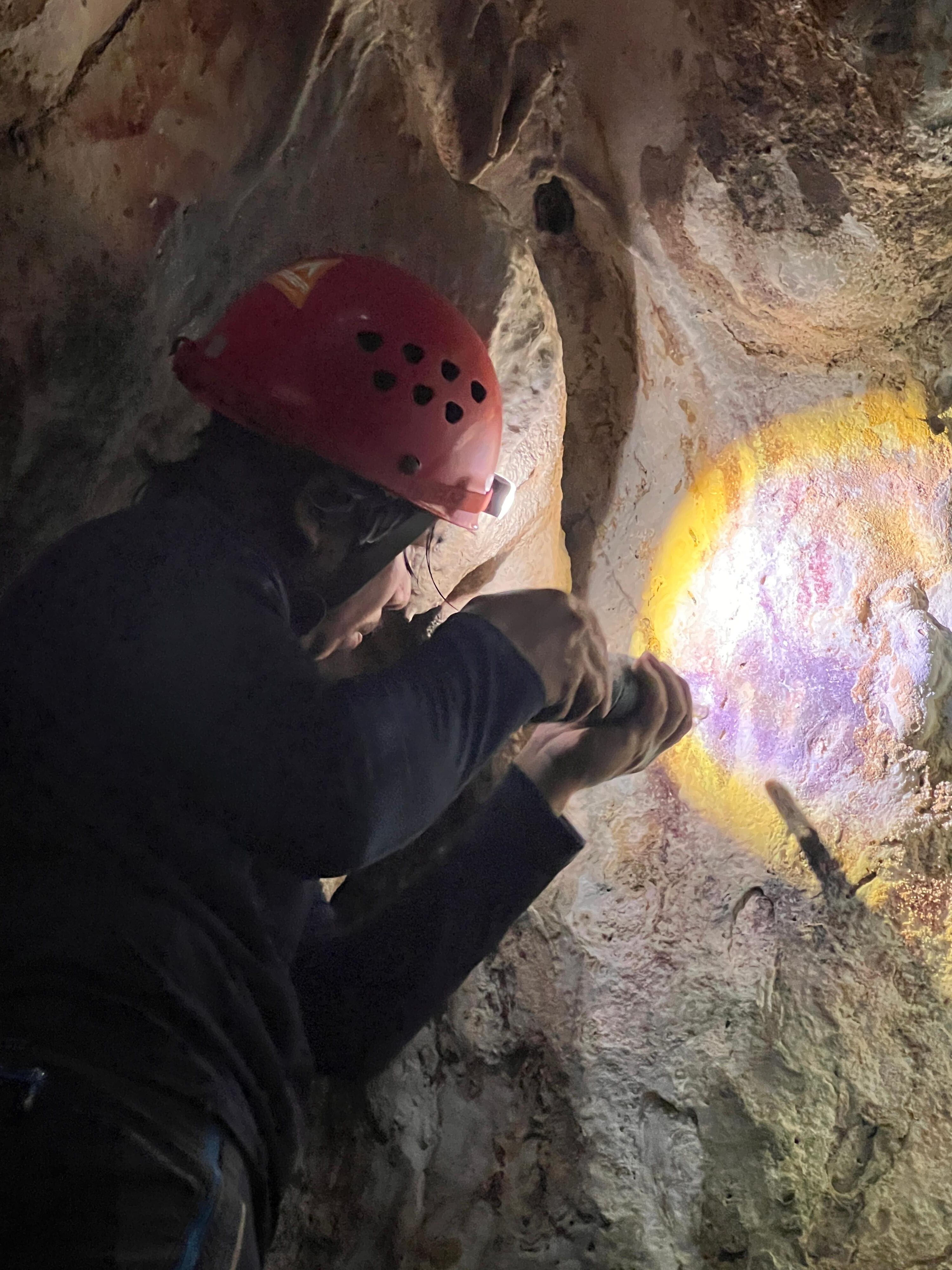
Adhi Oktaviana examines a slightly more recent hand stencil on the wall of Liang Metanduno.
Credit: Oktaviana et al. 2026
Adhi Oktaviana examines a slightly more recent hand stencil on the wall of Liang Metanduno. Credit: Oktaviana et al. 2026
Hands reaching out from the past
Archaeologist Adhi Agus Oktaviana, of Indonesia’s National Research and Innovation Agency, and his colleagues have spent the last six years surveying 44 rock art sites, mostly caves, on Sulawesi’s southeastern peninsula and the handful of tiny “satellite islands” off its coast. They found 14 previously undocumented sites and used rock formations to date 11 individual pieces of rock art in eight caves—including the oldest human artwork discovered so far.
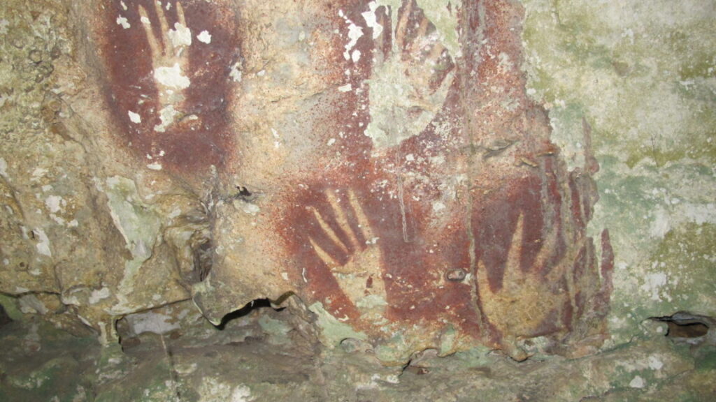
About 67,800 years ago, someone stood in the darkness of Liang Metanduno and placed their hand flat against the limestone wall. They, or maybe a friend, then blew a mixture of pigment and water onto the wall, covering and surrounding their hand. When they pulled their hand carefully away from the rock, careful not to disturb the still-wet paint, they left behind a crisp outline of their palm and fingers, haloed by a cloud of deep red.
The result is basically the negative of a handprint, and it’s a visceral, tangible link to the past. Someone once laid their hand on the cave wall right here, and you can still see its outline like a lingering ghost, reaching out from the other side of the rock. If you weren’t worried about damaging the already faded and fragile image, you could lay your hand in the same spot and meet them halfway.
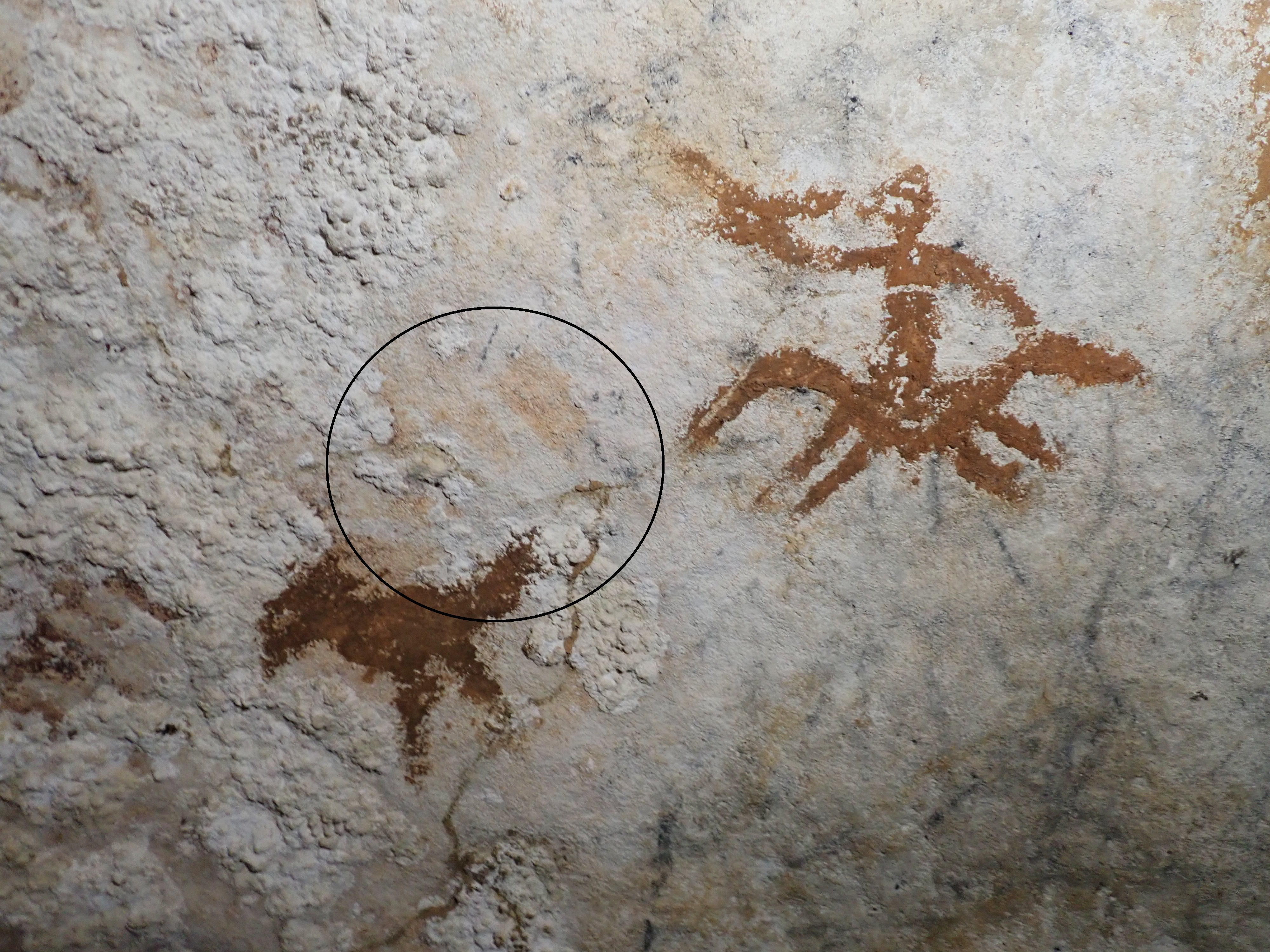
Today, the stencil is so faded that you can barely see it, but if you look closely, it’s there: a faint halo of reddish-orange pigment, outlining the top part of a palm and the base of the fingers. A thin, nearly transparent layer of calcite covers the faded shape, left behind by millennia of water dripping down the cave wall. The ratio of uranium and thorium in a sheet of calcite suggests that it formed at least 71,000 years ago—so the outline of the hand beneath it must have been left behind sometime before that, probably around 67,800 years ago.
The hand stencil is faded and overlain by more recent (but still ancient) artwork; it’s circled in black to help you find it in this photo.
Credit: Oktaviana et al. 2026
The hand stencil is faded and overlain by more recent (but still ancient) artwork; it’s circled in black to help you find it in this photo. Credit: Oktaviana et al. 2026
That makes Liang Metanduno the home of the oldest known artwork in the world, beating the previous contender (a Neanderthal hand stencil in Spain) by about 1,100 years.
“These findings support the growing view that Sulawesi was host to a vibrant and longstanding artistic culture during the late Pleistocene epoch,” wrote Oktaviana and his colleagues in their recent paper.
The karst caves of Sulawesi’s southwestern peninsula, Maros-Pangkep, are a treasure trove of deeply ancient artwork: hand stencils, as well as drawings of wild animals, people, and strange figures that seem to blend the two. A cave wall at Liang Bulu’Sipong 4 features a 4.5-meter-long mural of humanlike figures facing off against wild pigs and dwarf buffalo, and a 2024 study pushed the mural’s age back to 51,200 years ago, making it the second-oldest artwork that we know of (after the Liang Metanduno hand stencil in the recent study).
Archaeologists have only begun to rediscover the rock art of Maros-Pangkep in the last decade or so, and other areas of the island, like Southeast Sulawesi and its tiny satellite islands, have received even less attention—so we don’t know what’s still there waiting for humanity to find again after dozens of millennia. We also don’t know what the ancient artist was trying to convey with the outline of their hand on the cave wall, but part of the message rings loud and clear across tens of millennia: At least 67,800 years ago, someone was here.
Really, really ancient mariners
The hand stencil on the wall of Liang Metanduno is, so far, the oldest evidence of our presence in Wallacea, the group of islands stretched between the continental shelves of Asia and Australia. Populating these islands is “widely considered to have involved the first planned, long-distance sea crossing undertaken by our species,” wrote Oktaviana and his colleagues.
Back when the long-lost artist laid their hand on the wall, sea levels were about 100 meters lower than they are today. Mainland Asia, Sumatra, and Borneo would have been high points in a single landmass, joined by wide swaths of lowlands that today lie beneath shallow ocean. The eastern shore of Borneo would have been a jumping-off point, beyond which lay several dozen kilometers of water and (out of view over the horizon) Sulawesi.
The first few people may have washed ashore on Sulawesi on some misadventure: lost fishermen or tsunami survivors, maybe. But at some point, people must have started making the crossing on purpose, which implies that they knew how to build rafts or boats, how to steer them, and that land awaited them on the other side.
Liang Metanduno pushes back the timing of that crossing by nearly 10,000 years. It also lends strong support to arguments that people arrived in Australia earlier than archaeologists had previously suspected. Archaeological evidence from a rock shelter called Madjedbebe, in northern Australia, suggests that people were living there by 65,000 years ago. But that evidence is still debated (such is the nature of archaeology), and some archaeologists argue that humans didn’t reach the continent until around 50,000 years ago.
“With the discovery of rock art dating to at least 67,800 years ago in Sulawesi, a large island on the most plausible colonization route to Australia, it is increasingly likely that the controversial date of 65,000 years for the initial peopling of Australia is correct,” Griffith University archaeologists Adam Brumm, a coauthor of the recent study, told Ars.
Archaeologists Shinatria Adhityatama studies a panel of ancient paintings in Liang Metanduno.
Credit: Oktaviana et al. 2026
Archaeologists Shinatria Adhityatama studies a panel of ancient paintings in Liang Metanduno. Credit: Oktaviana et al. 2026
Archaeologists are still trying to work out exactly when, where, and how the first members of our species made the leap from the continent of Asia to the islands of Wallacea and, eventually, via several more open-water crossings, to Australia. Our picture of the process is pieced together from archaeological finds and models of ancient geography and sea levels.
“There’s been all sorts of work done on this (not by me), but often researchers consider the degree of intervisibility between islands, as well as other things like prevailing ocean currents and wind directions, changes in sea levels and how this affects the land area of islands and shorelines and so on,” Brumm said.
Most of those models suggest that people crossed the Makassar Strait from Borneo to Sulawesi, then island-hopped through what’s now Indonesia until they reached the western edge of New Guinea. At the time, lower sea levels would have left New Guinea, Australia, and New Zealand as one big land mass, so getting from New Guinea to what’s now Australia would actually have been the easy part.
A time capsule on the walls
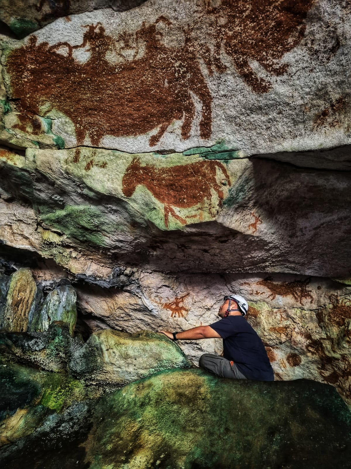
There’s a sense of deep, deep time in Liang Metanduno. The cave wall is a palimpsest on which the ancient hand stencil is nearly covered by a brown-hued drawing of a chicken, which (based on its subject matter) must have been added sometime after 5,000 years ago, when a new wave of settlers brought domesticated chickens to the island. It seems almost newfangled against the ghostly faint outline of the Paleolithic hand.
A few centimeters away is another hand stencil, done in darker pigment and dating to around 21,500 years ago; it overlays a lighter stencil dating to around 60,900 years ago. Over tens of thousands of years, generations of people returned here with the same impulse. We have no way of knowing whether visitors 21,500 years ago, or 5,000 years ago might have seen a more vibrantly decorated cave wall than what’s preserved today—but we know that they decided to leave their mark on it.
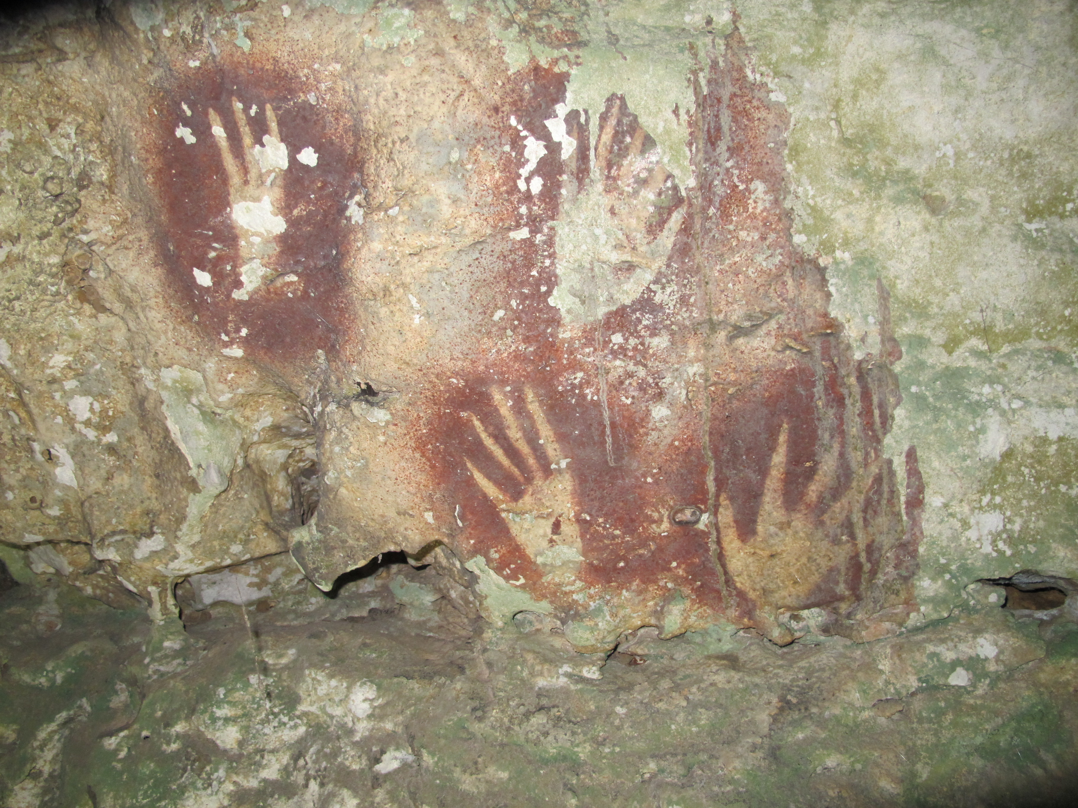
And the people who visited the cave 21,500 years ago shared a sense of style with the artists who left their hands outlined on the wall nearly 40,000 years before them: both handprints have slightly pointed fingers, as if the artist either turned their fingertip or just touched-up the outline with some paint after making the stencil. It’s very similar to other hand stencils, dated to around 17,000 years ago, from elsewhere on Sulawesi, and it’s a style that seems unique to the island.
“We may conclude that this regionally unique variant of stencil art is much older than previously thought,” wrote Oktaviana and his colleagues.
These 17,000-year-old hand stencils from Liang Jarie Maros, in another area of Sulawesi, bear a striking resemblance to the much older ones in Liang Metanduno.
Credit: OKtaviana et al. 2026
These 17,000-year-old hand stencils from Liang Jarie Maros, in another area of Sulawesi, bear a striking resemblance to the much older ones in Liang Metanduno. Credit: OKtaviana et al. 2026
And Homo sapiens wasn’t the first hominin species to venture as far as Indonesia; at least 200,000 years earlier, Homo erectus made a similar journey, leaving behind fossils and stone tools to mark that they, too, were once here. On some of the smaller islands, isolated populations of Homo erectus started to evolve along their own paths, eventually leading to diminutive species like Homo floresiensis (the O.G. hobbits) on Flores and Homo luzonensis on Luzon. Homo floresiensis co-discoverer Richard Roberts has suggested that other isolated hominin species may have existed on other scattered islands.
Anthropologists haven’t found any fossil evidence of these species after 50,000 years ago, but if our species was in Indonesia by nearly 68,000 years ago, we would have been in time to meet our hominin cousins.
Poisoned arrows or darts have long been used by cultures all over the world for hunting or warfare. For example, there are recipes for poisoning projective weapons, and deploying them in battle, in Greek and Roman historical documents, as well as references in Greek mythology and Homer’s Iliad and Odyssey. Chinese warriors over the ages did the same, as did the Gauls and Scythians, and some Native American populations.
Archaeologists have now found traces of a plant-based poison on several 60,000-year-old quartz Stone Age arrowheads found in South Africa, according to a new paper published in the journal Science Advances. That would make this the oldest direct evidence of using poisons on projectiles—a cognitively complex hunting strategy—and pushes the timeline for using poison arrows back into the Pleistocene.
The poisons commonly used could be derived from plants or animals (frogs, beetles, venomous lizards). Plant-based examples include curare, a muscle relaxant that paralyzes the victim’s respiratory system, causing death by asphyxiation. Oleander, milkweeds, or inee (onaye) contain cardiac glucosides. In Southeast Asia, the sap or juice of seeds from the ancar tree is smeared on arrowheads, which causes paralysis, convulsions, and cardiac arrest due to the presence of toxins like strychnine. Several species of aconite are known for their use as arrow poisons in Siberia and northern Japan.
According to the authors, up until now, the earliest direct evidence of poisoned arrows dates back to the mid-Holocene. For instance, scientists found traces of toxic glycoside residues on 4,000-year-old bone-tipped arrows recovered from an Egyptian tomb, as well as on bone arrow points from 6,700 years ago excavated from South Africa’s Kruger Cave. The only prior evidence of using poisons for hunting during the Pleistocene is a “poison applicator” found at Border Cave in South Africa, along with a lump of beeswax.
Milk of the poisonous onion
The authors sampled 10 quartz-backed arrowheads recovered from the Umhlatuzana Rock Shelter site in KwaZulu-Natal, South Africa. The results revealed that five of the 10 tested tips had traces of compounds found in Boophone disticha, aka gifbol (poisonous onion), sometimes called the century plant, which is common throughout South Africa. Various parts of the plant have been used as an analgesic (specifically a volatile oil called eugenol) as well as for poisonous hunting purposes. Its more toxic compounds include buphandrine, crinamidine, and buphanine; the latter is similar in effect to scopolamine and can cause hallucinations, coma, or death.
A recent study found lead in teeth from 2 million-year-old hominin fossils.
Our hominid ancestors faced a Pleistocene world full of dangers—and apparently one of those dangers was lead poisoning.
Lead exposure sounds like a modern problem, at least if you define “modern” the way a paleoanthropologist might: a time that started a few thousand years ago with ancient Roman silver smelting and lead pipes. According to a recent study, however, lead is a much more ancient nemesis, one that predates not just the Romans but the existence of our genus Homo. Paleoanthropologist Renaud Joannes-Boyau of Australia’s Southern Cross University and his colleagues found evidence of exposure to dangerous amounts of lead in the teeth of fossil apes and hominins dating back almost 2 million years. And somewhat controversially, they suggest that the toxic element’s pervasiveness may have helped shape our evolutionary history.
Joannes-Boyau and his colleagues took tiny samples of preserved enamel and dentin from the teeth of 51 fossils. In most of those teeth, the paleoanthropologists found evidence that these apes and hominins had been exposed to lead—sometimes in dangerous quantities—fairly often during their early years.
Tooth enamel forms in thin layers, a little like tree rings, during the first six or so years of a person’s life. The teeth in your mouth right now (and of which you are now uncomfortably aware; you’re welcome) are a chemical and physical record of your childhood health—including, perhaps, whether you liked to snack on lead paint chips. Bands of lead-tainted tooth enamel suggest that a person had a lot of lead in their bloodstream during the year that layer of enamel was forming (in this case, “a lot” means an amount measurable in parts per million).
In 71 percent of the hominin teeth that Joannes-Boyau and his colleagues sampled, dark bands of lead in the tooth enamel showed “clear signs of episodic lead exposure” during the crucial early childhood years. Those included teeth from 100,000-year-old members of our own species found in China and 250,000-year-old French Neanderthals. They also included much earlier hominins who lived between 1 and 2 million years ago in South Africa: early members of our genus Homo, along with our relatives Australopithecus africanus and Paranthropus robustus. Lead exposure, it turns out, is a very ancient problem.
Living in a dangerous world
This study isn’t the first evidence that ancient hominins dealt with lead in their environments. Two Neanderthals living 250,000 years ago in France experienced lead exposure as young children, according to a 2018 study. At the time, they were the oldest known examples of lead exposure (and they’re included in Joannes-Boyau and his colleagues’ recent study).
Until a few thousand years ago, no one was smelting silver, plumbing bathhouses, or releasing lead fumes in car exhaust. So how were our hominin ancestors exposed to the toxic element? Another study, published in 2015, showed that the Spanish caves occupied by other groups of Neanderthals contained enough heavy metals, including lead, to “meet the present-day standards of ‘contaminated soil.’”
Today, we mostly think of lead in terms of human-made pollution, so it’s easy to forget that it’s also found naturally in bedrock and soil. If that weren’t the case, archaeologists couldn’t use lead isotope ratios to tell where certain artifacts were made. And some places—and some types of rock—have higher lead concentrations than others. Several common minerals contain lead compounds, including galena or lead sulfide. And the kind of lead exposure documented in Joannes-Boyau and his colleagues’ study would have happened at an age when little hominins were very prone to putting rocks, cave dirt, and other random objects in their mouths.
Some of the fossils from the Queque cave system in China, which included a 1.8 million-year-old extinct gorilla-like ape called Gigantopithecus blacki, had lead levels higher than 50 parts per million, which Joannes-Boyau and his colleagues describe as “a substantial level of lead that could have triggered some developmental, health, and perhaps social impairments.”
Even for ancient hominins who weren’t living in caves full of lead-rich minerals, wildfires, or volcanic eruptions can also release lead particles into the air, and erosion or flooding can sweep buried lead-rich rock or sediment into water sources. If you’re an Australopithecine living upstream of a lead-rich mica outcropping, for example, erosion might sprinkle poison into your drinking water—or the drinking water of the gazelle you eat or the root system of the bush you get those tasty berries from… .
Our world is full of poisons. Modern humans may have made a habit of digging them up and pumping them into the air, but they’ve always been lying in wait for the unwary.
Cubic crystals of the lead-sulfide mineral galena.
Digging into the details
Joannes-Boyau and his colleagues sampled the teeth of several hominin species from South Africa, all unearthed from cave systems just a few kilometers apart. All of them walked the area known as Cradle of Humankind within a few hundred thousand years of each other (at most), and they would have shared a very similar environment. But they also would have had very different diets and ways of life, and that’s reflected in their wildly different exposures to lead.
A. africanus had the highest exposure levels, while P. robustus had signs of infrequent, very slight exposures (with Homo somewhere in between the two). Joannes-Boyau and his colleagues chalk the difference up to the species’ different diets and ecological niches.
“The different patterns of lead exposure could suggest that P. robustus lead bands were the result of acute exposure (e.g., wild forest fire),” Joannes-Boyau and his colleagues wrote, “while for the other two species, known to have a more varied diet, lead bands may be due to more frequent, seasonal, and higher lead concentration through bioaccumulation processes in the food chain.”
Did lead exposure affect our evolution?
Given their evidence that humans and their ancestors have regularly been exposed to lead, the team looked into whether this might have influenced human evolution. In doing so, they focused on a gene called NOVA1, which has been linked to both brain development and the response to lead exposure. The results were quite a bit short of decisive; you can think of things as remaining within the realm of a provocative hypothesis.
The NOVA1 gene encodes a protein that influences the processing of messenger RNAs, allowing it to control the production of closely related variants of a single gene. It’s notable for a number of reasons. One is its role in brain development; mice without a working copy of NOVA1die shortly after birth due to defects in muscle control. Its activity is also altered following exposure to lead.
But perhaps its most interesting feature is that modern humans have a version of the gene that differs by a single amino acid from the version found in all other primates, including our closest relatives, the Denisovans and Neanderthals. This raises the prospect that the difference is significant from an evolutionary perspective. Altering the mouse version so that it is identical to the one found in modern humans does alter the vocal behavior of these mice.
But work with human stem cells has produced mixed results. One group, led by one of the researchers involved in this work, suggested that stem cells carrying the ancestral form of the protein behaved differently from those carrying the modern human version. But others have been unable to replicate those results.
Regardless of that bit of confusion, the researchers used the same system, culturing stem cells with the modern human and ancestral versions of the protein. These clusters of cells (called organoids) were grown in media containing two different concentrations of lead, and changes in gene activity and protein production were examined. The researchers found changes, but the significance isn’t entirely clear. There were differences between the cells with the two versions of the gene, even without any lead present. Adding lead could produce additional changes, but some of those were partially reversed if more lead was added. And none of those changes were clearly related either to a response to lead or the developmental defects it can produce.
The relevance of these changes isn’t obvious, either, as stem cell cultures tend to reflect early neural development while the lead exposure found in the fossilized remains is due to exposure during the first few years of life.
So there isn’t any clear evidence that the variant found in modern humans protects individuals who are exposed to lead, much less that it was selected by evolution for that function. And given the widespread exposure seen in this work, it seems like all of our relatives—including some we know modern humans interbred with—would also have benefited from this variant if it was protective.
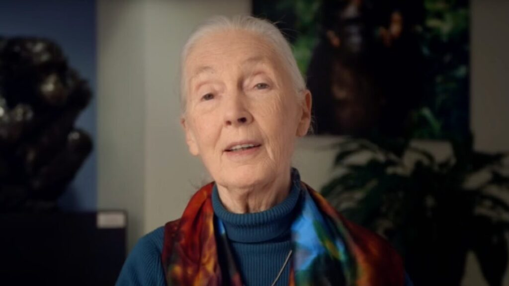
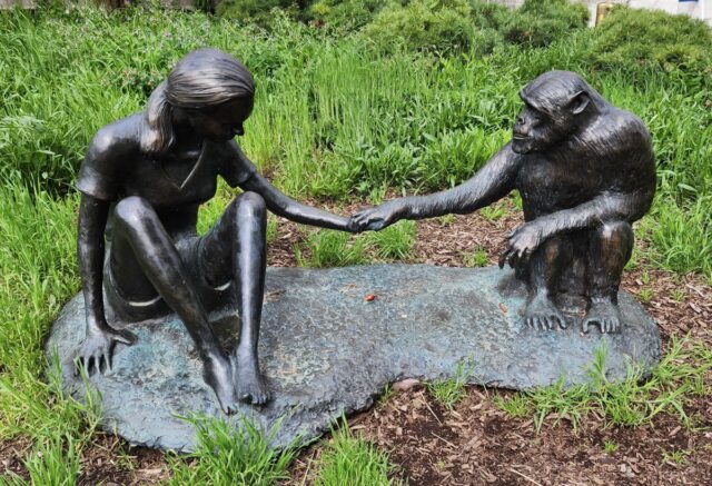
A sculpture of Jane Goodall and David Greybeard outside the Field Museum of Natural History in Chicago Credit: Geary/CC0
David Greybeard’s behavior also challenged the long-held assumption that chimpanzees were vegetarians. Goodall found that chimps would hunt and eat smaller primates like colobus monkeys as well, sometimes sharing the carcass with other troop members. She also recorded evidence of strong bonds between mothers and infants, altruism, compassion, and aggression and violence. For instance, dominant females would sometimes kill the infants of rival females, and from 1974 to 1978, there was a violent conflict between two communities of chimpanzees that became known as the Gombe Chimpanzee War.
Almost human
One of the more colorful chimps Goodall studied was named Frodo, who grew up to be an alpha male with a temperament very unlike his literary namesake. “As an infant, Frodo proved mischievous, disrupting Jane Goodall’s efforts to record data on mother-infant relationships by grabbing at her notebooks and binoculars,” anthropologist Michael Wilson of the University of Minnesota in Saint Paul recalled on his blog when Frodo died from renal failure in 2013. “As he grew older, Frodo developed a habit of throwing rocks, charging at, hitting, and knocking over human researchers and tourists.” Frodo attacked Wilson twice on Wilson’s first trip to Gombe, even beating Goodall herself in 1989, although he eventually lost his alpha status and “mellowed considerably” in his later years, per Wilson.
Goodall became so renowned around the world that she even featured in one of Gary Larson’s Far Side cartoons, in which two chimps are shown grooming when one finds a blonde hair on the other. “Conducting a little more ‘research’ with that Jane Goodall tramp?” the caption read. The JGI was not amused, sending Larson a letter (without Goodall’s knowledge) calling the cartoon an “atrocity,” but their objections were not shared by Goodall herself, who thought the cartoon was very funny when she heard of it. Goodall even wrote a preface to The Far Side Gallery 5. Larson, for his part, visited Goodall’s research facility in Tanzania in 1988, where he experienced Frodo’s alpha aggressiveness firsthand.
Goodall founded the JGI in 1977 and authored more than 27 books, most notably My Friends, the Wild Chimpanzees (1967), In the Shadow of Man (1971), and Through a Window (1990). There was some initial controversy around her 2014 book Seeds of Hope, co-written with Gail Hudson, when portions were found to have been plagiarized from online sources; the publisher postponed publication so that Goodall could revise the book and add 57 pages of endnotes. (She blamed her “chaotic note-taking” for the issue.) National Geographic released a full-length documentary last year about her life’s work, drawing from over 100 hours of previously unseen archival footage.
Now that we know what Denisovans looked like, they’re turning up everywhere.
This digital reconstruction makes Yunxian 2 look liess like a Homo erectus and more like a Denisovan (or Homo longi, according to the authors). Credit: Feng et al. 2025
A fossil skull from China that made headlines last week may or may not be a million years old, but it’s probably closely related to Denisovans.
The fossil skull, dubbed Yunxian 2, is one of three unearthed from a terrace alongside the Han River, in central China, in a layer of river sediment somewhere between 600,000 and 1 million years old. Archaeologists originally identified them as Homo erectus, but Hanjiang Normal University paleoanthropologist Xiaobo Feng and his colleagues’ recent digital reconstruction of Yunxian 2 suggests the skulls may actually have belonged to someone a lot more similar to us: a hominin group defined as a species called Homo longi or a Denisovan, depending on who’s doing the naming.
The recent paper adds fuel—and a new twist—to that debate. And the whole thing may hinge on a third skull from the same site, still waiting to be published.
This digital reconstruction makes Yunxian 2 look less like a Homo erectus and more like a Denisovan (or Homo longi, according to the authors). Credit: Feng et al. 2025
Denisovan or Homo longi?
The Yunxian skull was cracked and broken after hundreds of thousands of years under the crushing weight of all that river mud, but the authors used CT scans to digitally put the pieces back together. (They got some clues from a few intact bits of Yunxian 1, which lay buried in the same layer of mud just 3 meters away.) In the end, Feng and his colleagues found themselves looking at a familiar face; Yunxian 2 bears a striking resemblance to a 146,000-year-old Denisovan skull.
That skull, from Harbin in northeast China, made headlines in 2021 when a team of paleoanthropologists claimed it was part of an entirely new species, which they dubbed Homo longi. According to that first study, Homo longi was a distinct hominin species, separate from us, Neanderthals, and even Denisovans. That immediately became a point of contention because of features the skull shared with some other suspected Denisovan fossils.
Earlier this year, a team of researchers, which included one of the 2021 study’s authors, took samples of ancient proteins preserved in the Harbin skull; of the 95 proteins they found, three of them matched proteins only encoded in Denisovan DNA. While the June 2025 study suggested that Homo longi was a Denisovan all along, the new paper draws a different conclusion: Homo longi is a species that happens to include the population we’ve been calling Denisovans. As study coauthor Xijun Ni, of the Chinese Academy of Sciences, puts it in an email to Ars Technica, “Given their similar age range, distribution areas, and available morphological data, it is likely that Denisovans belong to the Homo longi species. However, little is known about Denisovan morphology.”
Of course, that statement—that we know little about Denisovan morphology (the shapes and features of their bones)—only applies if you don’t accept the results of the June 2025 study mentioned above, which clocked the Harbin skull as a Denisovan and therefore told us what one looks like.
And Feng and his colleagues, in fact, don’t accept those results. Instead, they consider Harbin part of some other group of Homo longi, and they question the earlier study’s methods and results. “The peptide sequences from Harbin, Penghu, and other fossils are too short and provide conflicting information,” Ni tells Ars Technica. Feng and his colleagues also question the results of another study, which used mitochondrial DNA to identify Harbin as a Denisovan.
In other words, Feng and his colleagues are pretty invested in defining Homo longi as a species and Denisovans as just one sub-group of that species. But that’s hard to square with DNA data.
Alas, poor Yunxian 2, I knew him well
Yunxian 2 has a wide face with high, flat cheekbones, a wide nasal opening, and heavy brows. Its cranium is higher and rounder than Homo erectus (and the original reconstruction, done in the 1990s), but it’s still longer and lower than is normal for our species. Overall, it could have held about 1,143 cubic centimeters of brain, which is in the ballpark of modern people. But its shape may have left less room for the frontal lobe (the area where a lot of social skills, logic, motor skills, and executive function happen) than you’d expect in a Neanderthal or a Homo sapiens skull.
Feng and his colleagues measured the distances between 533 specific points on the skull: anatomical landmarks like muscle attachment points or the joints between certain bones. They compared those measurements to ones from 26 fossil hominin skulls and several-dozen modern human skulls, using a computer program to calculate how similar each skull was to all of the others.
Yunxian 2 fits neatly into a lookalike group with the Harbin skull, along with two other skulls that paleoanthropologists have flagged as belonging to either Denisovans or Homo longi. Those two skulls are a 200,000- to 260,000-year-old skull found in Dali County in northwestern China and a 260,000-year-old skull from Jinniushi (sometimes spelled Jinniushan) Cave in China.
Those morphological differences suggest some things about how the individuals who once inhabited these skulls might have been related to each other, but that’s also where things get dicey.
An older reconstruction of the Yunxian 2 skull gives it a flatter look. Credit: government of Wuhan
Digging into the details
Most of what we know about how we’re related to our closest extinct hominin relatives (Neanderthals and Denisovans) comes from comparing our DNA to theirs and tracking how small changes in the genetic code build up over time. Based on DNA, our species last shared a common ancestor with Neanderthals and Denisovans sometime around 750,000 years ago in Africa. One branch of the family tree led to us; the other branch split again around 600,000 years ago, leading to Neanderthals and Denisovans (or Homo longi, if you prefer).
In other words, DNA tells us that Neanderthals and Denisovans are more closely related to each other than either is to us. (Unless you’re looking at mitochondrial DNA, which suggests that we’re more closely related to Neanderthals than to Denisovans; it’s complicated, and there’s a lot we still don’t understand.)
“Ancient mtDNA and genomic data show different phylogenetic relationships among Denisovans, Neanderthals and Homo sapiens,” says Ni. So depending on which set of data you use and where your hominin tree starts, it can be possible to get different answers about who is most closely related to whom. The fact that all of these groups interbred with each other can explain this complexity, but makes building family trees challenging.
It is very clear, however, that Feng and his colleagues’ picture of the relationships between us and our late hominin cousins, based on similarities among fossil skulls in their study, looks very different from what the genomes tell us. In their model, we’re more closely related to Denisovans, and the Neanderthals are off on their own branch of the family tree. Feng and his colleagues also say those splits happened much earlier, with Neanderthals branching off on their own around 1.38 million years ago; we last shared a common ancestor with Homo longi around 1 million years ago.
That’s a big difference from DNA results, especially when it comes to timing. And the timing is likely to be the biggest controversy here. In a recent commentary on Feng and his colleagues’ study, University of Wisconsin paleoanthropologist John Hawks argues that you can’t just leave genetic evidence out of the picture.
“What this research should have done is to put the anatomical comparisons into context with the previous results from DNA, especially the genomes that enable us to understand the relationships of Denisovan, Neanderthal, and modern human groups,” Hawks writes.
(It’s worth a side note that most news stories describe Yunxian 2 as being a million years old, and so do Feng and his colleagues. But electron spin resonance dating of fossil animal bones from the same sediment layer suggests the skull could be as young as 600,000 years old or as old as 1.1 million. That still needs to be narrowed down to everyone’s satisfaction.)
What’s in a name?
Of course, DNA also tells us that even after all this branching and migrating, the three species were still similar enough to reproduce, which they did several times. Many groups of modern people still carry traces of Neanderthal and Denisovan DNA in their genomes, courtesy of those exchanges. And some ancient Neanderthal populations were carrying around even older chunks of human DNA in the same way. That arguably makes species definitions a little fuzzy at best—and maybe even irrelevant.
“I think all these groups, including Neanderthals, should be recognized within our own species, Homo sapiens,” writes Hawks. Hawks contends that the differences among these hominin groups “were the kind that evolve among the populations of a single species over time, not starkly different groups that tread the landscape in mutually unrecognizeable ways.”
But humans love to classify things (a trait we may have shared with Neanderthals and Denisovans), so those species distinctions are likely to persist even if the lines between them aren’t so solid. As long as that’s the case, names and classifications will be fodder for often heated debate. And Feng’s team is staking out a position that’s very different from Hawks’. “‘Denisovan’ is a label for genetic samples taken from the Denisova Cave. It should not be used everywhere. Homo longi is a formally named species,” says Ni.
Technically, Denisovans don’t have a formal species name, a Latinized moniker like Homo erectus that comes with a clear(ish) spot on the family tree. Homo longi would be a more formal species name, but only if scientists can agree on whether they’re actually a species.
An archaeologist comes face to face with the Yunxian 3 skull Credit: government of Wuhan
The third Yunxian skull
Paleoanthropologists unearthed a third skull from the Yunxian site in 2022. It bears a strong resemblance to the other two from the area (and is apparently in better shape than either of them), and it dates to about the same timeframe. A 2022 press release describes it as “the most complete Homo erectus skull found in Eurasia so far,” but if Feng and his colleagues are right, it may actually be a remarkably complete Homo longi (and/or Denisovan) skull. And it could hold the answers to many of the questions anthropologists like Feng and Hawks are currently debating.
“It remains pretty obvious that Yunxian 3 is going to be central to testing the relationships of this sample [of fossil hominins in Feng and colleagues’ paper],” writes Hawks.
The problem is that Yunxian 3 is still being cleaned and prepared. Preparing a fossil is a painstaking, time-consuming process that involves very carefully excavating it from the rocky matrix it’s embedded in, using everything from air-chisels to paintbrushes. And until that’s done and a scientific report on the skull is published, other paleoanthropologists don’t have access to any information about its features—which would be super useful for figuring out how to define whatever group we eventually decide it belongs to.
For the foreseeable future, the relationships between us and our extinct cousins (or at least our ideas about those relationships) will keep changing as we get more data. Eventually, we may have enough data from enough fossils and ancient DNA samples to form a clearer picture of our past. But in the meantime, if you’re drawing a hominin family tree, use a pencil.
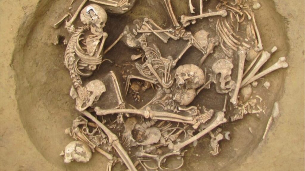
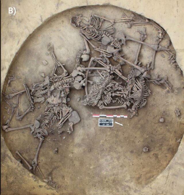
A local Neolithic community in northeastern France may have clashed with foreign invaders, cutting off limbs as war trophies and otherwise brutalizing their prisoners of war, according to a new paper published in the journal Science Advances. The findings challenge conventional interpretations of prehistoric violence as bring indiscriminate or committed for pragmatic reasons.
Neolithic Europe was no stranger to collective violence of many forms, such as the odd execution and massacres of small communities, as well as armed conflicts. For instance, we recently reported on an analysis of human remains from 11 individuals recovered from El Mirador Cave in Spain, showing evidence of cannibalism—likely the result of a violent episode between competing Late Neolithic herding communities about 5,700 years ago. Microscopy analysis revealed telltale slice marks, scrape marks, and chop marks, as well as evidence of cremation, peeling, fractures, and human tooth marks.
This indicates the victims were skinned, the flesh removed, the bodies disarticulated, and then cooked and eaten. Isotope analysis indicated the individuals were local and were probably eaten over the course of just a few days. There have been similar Neolithic massacres in Germany and Spain, but the El Mirador remains provide evidence of a rare systematic consumption of victims.
Per the authors of this latest study, during the late Middle Neolithic, the Upper Rhine Valley was the likely site of both armed conflict and rapid cultural upheaval, as groups from the Paris Basin infiltrated the region between 4295 and 4165 BCE. In addition to fortifications and evidence of large aggregated settlements, many skeletal remains from this period show signs of violence.
Friends or foes?
Overhead views of late Middle Neolithic violence-related human mass deposits in Pit 124 of the Alsace region, France. Credit: Philippe Lefranc, INRAP
Archaeologist Teresa Fernandez-Crespo of Spain’s Valladolid University and co-authors focused their analysis on human remains excavated from two circular pits at the Achenheim and Bergheim sites in Alsace in northwestern France. Fernandez-Crespo et al. examined the bones and found that many of the remains showed signs of unhealed trauma—such as skull fractures—as well as the use of excessive violence (overkill), not to mention quite a few severed left upper limbs. Other skeletons did not show signs of trauma and appeared to have been given a traditional burial.
In the late 1500s, a few decades after the khipu in this recent study was made, an Indigenous chronicler named Guaman Poma de Ayala described how older women used khipu to “keep track of everything” in aqllawasai: places that basically functioned as finishing schools for Inca girls. Teenage girls, chosen by local nobles, were sent away to live in seclusion at the aqllawasai to weave cloth, brew chicha, and prepare food for ritual feasts.
What happened to the girls after aqllawasai graduation was a mixed bag. Some of them were married (or given as concubines) to Inca nobles, others became priestesses, and some ended up as human sacrifices. But some of them actually got to go home again, and they probably took their knowledge of khipu with them.
“I think this is the likely way in which khipu literacy made it into the countryside and the villages,” said Hyland. “These women, who were not necessarily elite, taught it to their children, etc.” That may be where the maker of KH0631 learned their skills: either in an aqllawasai or from a graduate of one (we still don’t know this particular khipu-maker’s gender).
“Science confirming what they already knew”
The finely crafted khipu turning out to be the work of a commoner shows that numeracy was widespread and surprisingly egalitarian in the Inca empire, but it also reveals a centuries-long thread connecting the Inca and their descendants.
Modern people—the descendants of the Inca—still use khipu today in some parts of Peru and Chile. Some scholars (mostly non-Indigenous ones) have argued that these modern khipu weren’t really based on knowledge passed down for centuries but were instead just a clumsy attempt to copy the Inca technology. But if commoners were using khipu in the Inca empire, it makes sense for that knowledge to have been passed down to modern villagers.
“It points to a continuity between Inka and modern khipus,” said Hyland. “In the few modern villages with living khipu traditions, they already believe in this continuity, so it would be the case of science confirming what they already know.”
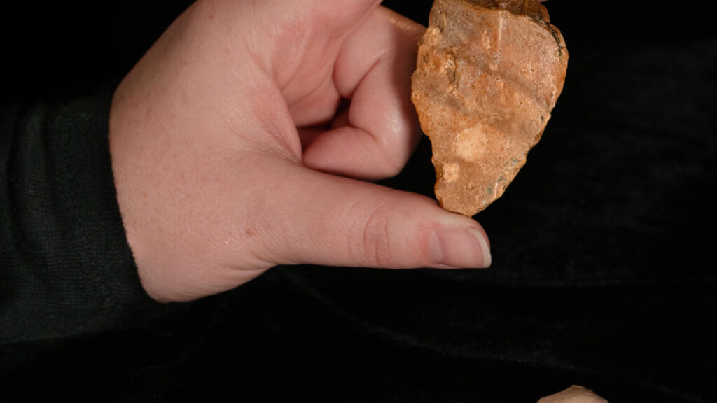
Some stone tools found near a river on the Indonesian island of Sulawesi suggest that the first hominins had reached the islands by at least 1.04 million years ago. That’s around the same time that the ancestors of the infamously diminutive “Hobbits” may have reached the island of Flores.
Archaeologist Budianto Hakim of Indonesia’s National Research and Innovation Agency and his colleagues were the ones who recently unearthed the tools from a site on Sulawesi. Although a handful of stone flakes from that island don’t tell us who the ancestors of the small species were or how they reached remote islands like Flores and Luzon, the tools are one more piece in the puzzle. And this handful of stone flakes may eventually play a role in helping us understand how other hominin species conquered most of the world long before we came along.
Crossing the ocean a million years ago
Sometimes the deep past leaves the smallest traces. At the Calio site, a sandstone outcrop in what’s now a cornfield outside the village of Ujung in southern Sulawesi, people left behind just a handful of sharp stone flakes roughly a million years ago. There are seven of them, ranging from 22 to 60 millimeters long, and they’re scratched, worn, and chipped from tumbling around at the bottom of a river. But it’s still clear that they were once shaped by skilled human—or at least human-like—hands that used hard stones as hammers to make sharp-edged chert flakes for cutting and scraping.
The oldest of these tools is likely to be between 1.04 and 1.48 million years old. Hakim and his colleagues dated teeth from a wild pig to around 1.26 million years ago. They were part of a jawbone archaeologists unearthed from a layer just above the oldest flake. Throw in some statistical modeling, and you get the range of likely dates for the stone flake buried in the deepest layer of soil.
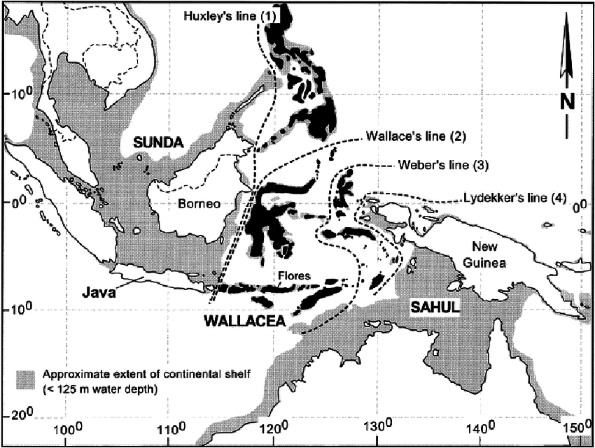
Even the younger end of that estimate would make these tools the oldest evidence yet of hominins (of any species) in the islands of Indonesia and the Philippines. This area, sometimes called Wallacea, lies between the continents of Asia and Australia, separated from both by wide channels of deep ocean.
“But the Calio site has yet to yield any hominin fossils,” said Brumm, “so while we now know there were tool-makers on Sulawesi a million years ago, their identity remains a mystery.” But they may be related to the Hobbits, a short-statured group of hominins who lived hundreds of kilometers away on the island of Flores until around 50,000 years ago.
“The discovery of Early Pleistocene artifacts at Calio suggests that Sulawesi was populated by hominins at around the same time as Flores, if not earlier,” wrote Hakim and his colleagues in their recent paper.
The Flores connection
The islands that now make up Indonesia and the Philippines have been a hominin hotspot for at least a million years. Our species wandered onto the scene sometime between 63,000 and 73,000 years ago, but at least one other hominin species had already been there for at least a million years. We’re just not sure exactly who they were, when they arrived, or how.
“Precisely when hominins first crossed to Sulawesi remains an open question, as does the taxonomic affinity of the colonizing population,” the authors note.
This map shows the islands of Wallacea. The large one just east of Java is Sulawesi. Credit: Darren O’Connell
That’s why the handful of stone tools the team recently unearthed at Calio matter: They’re another piece of that puzzle, albeit a small one. Every slightly older date is one step closer to the first hominin tools, bones, or footprints in these islands, and another pin on the map of who was where and when.
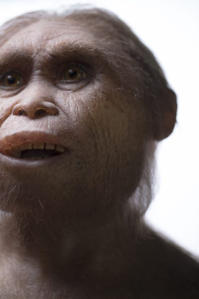
And that map is accumulating quite a lot of pins, representing an ever-increasing number of species. Once the first hominins made it across the Makassar Strait, they found themselves in isolated groups on islands cut off from the mainland—and each other—so the hominin family tree started branching very quickly. On at least two islands, Flores and Luzon, those original hominin settlers eventually gave rise to local species, Homo floresiensis and Homo luzonensis. And University of Wollongong paleoanthropologist Richard Roberts, a co-discoverer of Homo floresiensis, thinks there are probably more isolated island hominin species.
In 2019, when Homoluzonensis was first described, Roberts told Ars, “These new fossils, and the assignation of them to a new species (Homo luzonensis), fulfills one of the predictions Mike Morwood and others (myself included) made when we first reported (15 years ago!) the discovery of Homo floresiensis: that other unknown species of hominins would be found in the islands of Southeast Asia.”
Both Homo floresiensis (the original “Hobbits”) and Homo luzonensis were short, clocking in at just over a meter tall. Their bones and teeth are different enough from each other to set them apart as a unique species, but they have enough in common that they probably share a common ancestor—one they don’t share with us. They’re more like our distant cousins, and the islands of Wallacea may have been home to many other such cousins, if Roberts and his colleagues are correct.
Complicated family history
But who was the common ancestor of all these hominin cousins? That’s where things get complicated (as if they weren’t already). Most paleoanthropologists lean toward Homo erectus, but there’s a chance—along with some tantalizing hints, and no direct evidence—that much more ancient human relatives called Australopithecines may have made the journey a million (or two) years before Homo erectus.
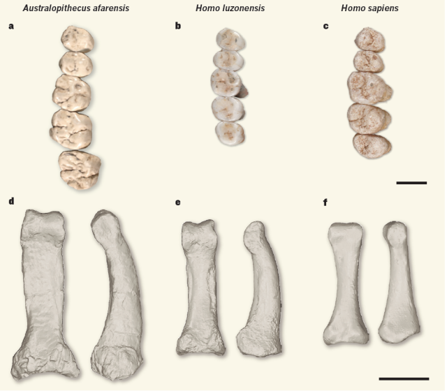
Finger and toe bones from Homo luzonensis are curved, as if they spent as much of their lives climbing trees as walking. That’s more like Australopithecines than any member of our genus Homo. But their teeth are smaller and shaped more like ours. Anthropologists call this mix of features a mosaic, and it can make it tough to figure out how hominin species are related. That’s part of why the question of when the ancestors of the Hobbits arrived on their respective islands is so important.
Compare the teeth and phalanx of Homo luzonensis to those of Homo sapiens (right) and Australopithecus afarensis (left). Credit: Tocheri 2019
We don’t know the answer yet, but we do know that someone was making stone tools on Flores by 1.02 million years ago. Those toolmakers may have been Homo erectus, Australopithecines, or something already recognizable as tiny Homo floresiensis. The Hobbits (or their ancestors) were distinctly “Hobbity” by around 700,000 years ago; fossil teeth and bones from a handful of hominins at a site called Mata Menge make that clear. The Hobbits discovered at Liang Bua Cave on Flores date to somewhere between 50,000 and 100,000 years ago.
Meanwhile, 2,800 kilometers away on the island of Luzon, the oldest stone tools, along with their obvious cut marks left behind on animal bones, date back to 700,000 years ago. That’s as old as the Mata Menge Hobbits on Flores. The oldest Homo luzonensis fossils are between 50,000 and 67,000 years old. It’s entirely possible that older evidence, of the island’s original settlers and of Homo luzonensis, may eventually be found, but until then, we’re left with a lot of blank space and a lot of questions.
And now we know that the oldest traces of hominin presence on Sulawesi is at least 1.04 million years old. But might Sulawesi have its own diminutive hominins?
So are there more Hobbits out there?
“Sulawesi is a wild card—it’s like a mini-continent in itself,” said Brumm. “If hominins were cut off on this huge and ecologically rich island for a million years, would they have undergone the same evolutionary changes as the Flores hobbits? Or would something totally different have happened?”
Reconstruction of Homo floresiensis by Atelier Elisabeth Daynes. Credit: Kinez Riza
A phenomenon called island dwarfism played a role in Homo floresiensis‘ evolution; species that live in relative isolation on small islands tend to evolve into either much larger or much smaller versions of their ancestors (which is why the Hobbits shared their island home with pygmy elephants and giant moas). But how small does an island need to be before island dwarfism kicks in? Sulawesi is about 12 times as large as Flores, for example. So what might the descendants of the Calio toolmakers have looked like by 100,000 years ago?
That’s something that we’ll only know if archaeologists on Sulawesi, like Hakim and his team, find fossil remains of those hominins.
Seafarers or tsunami survivors?
Understanding exactly when hominins first set foot on the island of Sulawesi might eventually help us figure out how they got there. These islands are thousands of kilometers from the Southeast Asian mainland and from each other, so getting there would have meant crossing vast stretches of deep, open ocean.
Archaeologists haven’t found any evidence that anyone who came before our species built boats or rafts, although those watercraft would have been made of materials that tend to decay pretty quickly, so even scraps of ancient wood and rope are extremely rare and lucky finds. But some ancient hominins did have a decent grasp of all the basic skills they’d need for at least a simple raft: woodworking and rope-making.
Another possibility is that hominins living on the coast of mainland Southeast Asia could have been swept out to sea by a tsunami, and some of them could have been lucky enough to survive the misadventure and wash ashore someplace like Sulawesi, Flores, or Luzon (RIP to any others). But for that scenario to work, enough hominins would have had to reach each island to create a lasting population, and it probably had to happen more than once to end up with hominin groups on at least three distant islands.
Either way, it’s no small feat, even for a Hobbit with small feet.
Traditionally, Indigenous peoples almost universally viewed thoroughly putrefied, maggot-infested animal foods as highly desirable fare, not starvation rations. In fact, many such peoples routinely and often intentionally allowed animal foods to decompose to the point where they were crawling with maggots, in some cases even beginning to liquefy.
This rotting food would inevitably emit a stench so overpowering that early European explorers, fur trappers, and missionaries were sickened by it. Yet Indigenous peoples viewed such foods as good to eat, even a delicacy. When asked how they could tolerate the nauseating stench, they simply responded, “We don’t eat the smell.”
Neanderthals’ cultural practices, similar to those of Indigenous peoples, might be the answer to the mystery of their high δ¹⁵N values. Ancient hominins were butchering, storing, preserving, cooking, and cultivating a variety of items. All these practices enriched their paleo menu with foods in forms that nonhominin carnivores do not consume. Research shows that δ¹⁵N values are higher for cooked foods, putrid muscle tissue from terrestrial and aquatic species, and, with our study, for fly larvae feeding on decaying tissue.
The high δ¹⁵N values of maggots associated with putrid animal foods help explain how Neanderthals could have included plenty of other nutritious foods beyond only meat while still registering δ¹⁵N values we’re used to seeing in hypercarnivores.
We suspect the high δ¹⁵N values seen in Neanderthals reflect routine consumption of fatty animal tissues and fermented stomach contents, much of it in a semi-putrid or putrid state, together with the inevitable bonus of both living and dead ¹⁵N-enriched maggots.
What still isn’t known
Fly larvae are a fat-rich, nutrient-dense, ubiquitous, and easily procured insect resource, and both Neanderthals and early Homo sapiens, much like recent foragers, would have benefited from taking full advantage of them. But we cannot say that maggots alone explain why Neanderthals have such high δ¹⁵N values in their remains.
Several questions about this ancient diet remain unanswered. How many maggots would someone need to consume to account for an increase in δ¹⁵N values above the expected values due to meat eating alone? How do the nutritional benefits of consuming maggots change the longer a food item is stored? More experimental studies on changes in δ¹⁵N values of foods processed, stored, and cooked following Indigenous traditional practices can help us better understand the dietary practices of our ancient relatives.
The mandible had been separated from the skeleton, and both it and the neurocranium are incomplete, so they were reconstructed and consolidated with plaster. CT scanning made it possible to check that older reconstructive work to ensure it had not masked any elements that may have influenced the taxonomic classification, per the authors. The team also scanned the skulls of three Homo neanderthalensis skulls in the collection of the Musee de l’Homme in Paris and compared those skull characteristics with the Skuhl Cave skull and mandible.
They concluded that the neurocranium’s parietal and temporal bones, and the shape of the bony labyrinth, were consistent with Homo sapiens. However, other features, like the receded and high location of the posterior rim of the foramen magnum, indicated a possible Neanderthal lineage. And the mandible showed distinct Neanderthal characteristics, leading to the determination that the child was a hybrid of the two species.
Co-author Anne Dambricourt Malassé of the Institute of Human Paleontology in Paris admitted that she once thought such a hybridization would not have been viable; the results of their analysis demonstrate that it is possible, although the child in question died very young. These findings may also prompt a revisiting of the longstanding assumption that Skuhl Cave was a Homo sapiens gravesite.
“This study is maybe the first that has put the Skhul child’s remains on a scientific basis,” John Hawks of the University of Wisconsin-Madison, who wasn’t involved with the study, told New Scientist. “The old reconstruction and associated work, literally set in plaster, did not really enable anyone to compare this child with a broader array of recent children to understand its biology.” That said, he cautioned that without extracting and analyzing a DNA sample, one can’t make a definitive determination: “Human populations are variable and there can be a lot of variability in their appearance and physical form even without mixing with ancient groups like Neanderthals.”