
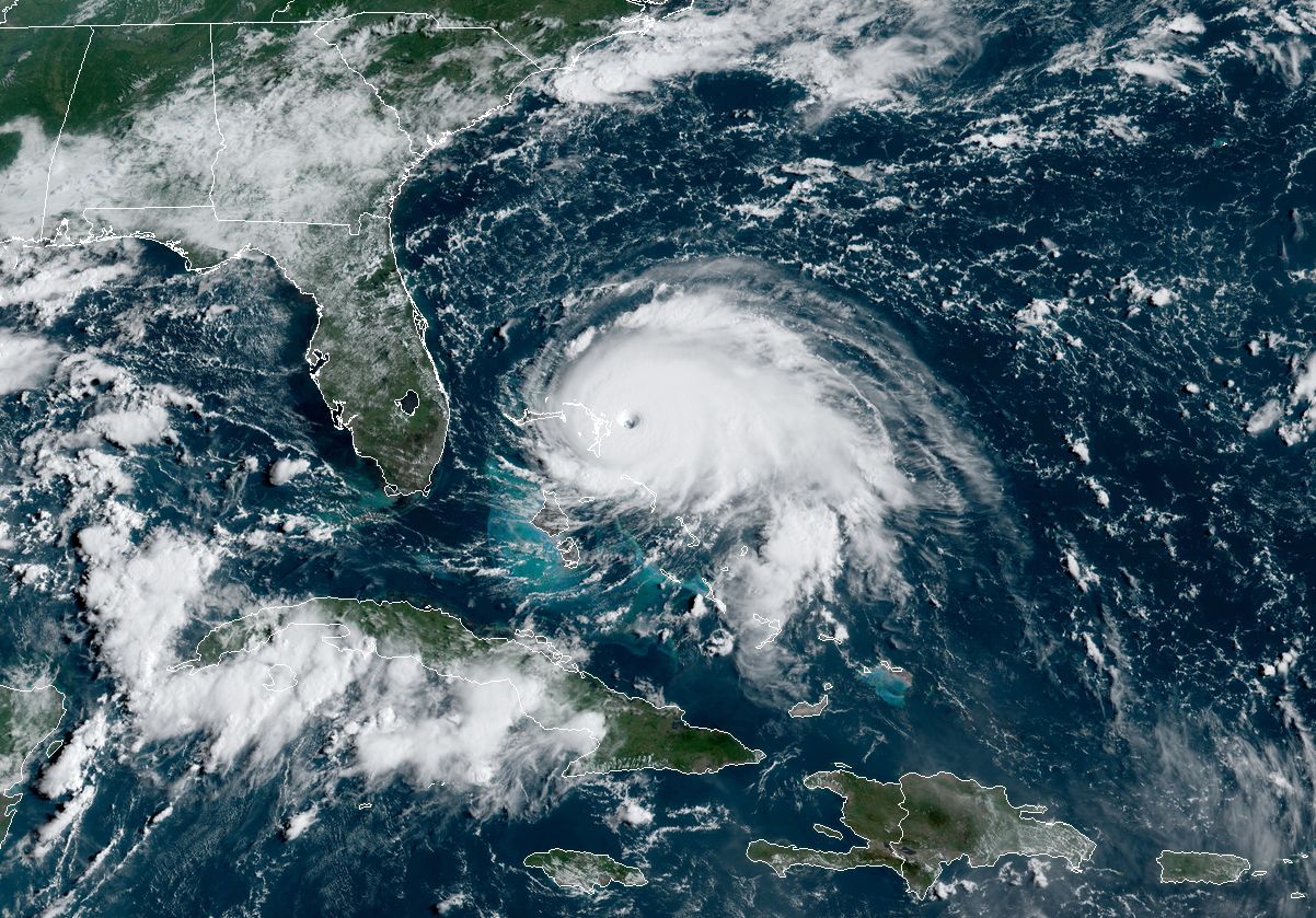
Enlarge / Hurricane Dorian’s satellite appearance on a Sunday morning in 2019.
NOAA
Later this week, the US federal agency charged with weather forecasting will release its outlook for the 2024 Atlantic hurricane season at a news conference in Washington, DC. But we already know what the National Oceanic and Atmospheric Administration (NOAA) forecast will say: This year will likely be extremely active in the Atlantic Ocean, Gulf of Mexico, and Caribbean Sea.
The Atlantic season formally begins on June 1, and based on current trends, the first named storm may not develop until the middle of the month or later. But make no mistake—when the light switches on later this summer, the season is likely to be a blockbuster.
Why? Because the oceans are screaming at us.
In the Pacific Ocean, there is an increasingly high likelihood of a La Niña developing during the critical months of August, September, and October, when the Atlantic season peaks. This has a couple of effects in the Atlantic. First, through a combination of weaker trade winds and westerlies over the tropical Atlantic, La Niña tends to create a more placid atmosphere. This leads to less wind shear, which is favorable for the development and strengthening of tropical storms and hurricanes.
Secondly, there is a growing amount of data to support the idea that Atlantic storms tend to recurve into the open ocean less during La Niña years, with fewer systems becoming “fish storms” that do not interact with landmasses. Rather, a stronger high-pressure system such as the Bermuda High steers such storms westward into the Caribbean Sea or Gulf of Mexico—and potentially toward the United States.
Another signal from the oceans is the extremely warm temperatures in the tropical Atlantic right now. Due at least in part to climate change, the ocean is anomalously warm, with seas closer to August “normals” than what is to be expected in late May.
So, if you put together sizzling seas and low wind shear, you get a recipe for lots of hurricane activity.
Blockbuster forecasts
We’ve already seen this in seasonal forecasts from other outfits. The venerable forecast team at Colorado State University, led by Phil Klotzbach, has predicted an “extremely active” 2024 season with 23 named storms and 11 hurricanes. Each of these values is about 60 percent higher than a typical season.
One of the pre-season forecasts that most caught my attention came from the University of Pennsylvania, led by scientists Michael Mann, Shannon Christiansen, and Michael Kozar. They predict an astounding 33 named storms in the tropical Atlantic this year. This would eclipse the previous record of 30 named storms, set in 2020.
It might be easy to dismiss the Pennsylvania forecast. In some corners of the Internet, Mann is viewed as a master of climate doomerism for his outspoken views on the perils of a warming world. But if anything, since its first issuance in 2007, Mann’s forecast has proven to be conservative. In 2020, for example, the team predicted 20 named storms. So it’s a sobering outlook.
If you prefer a purely numerical prediction, the European Centre for Medium-Range Weather Forecasts—which produces the most reliable computational weather forecasts in the world—has been issuing seasonal hurricane outlooks for three decades.
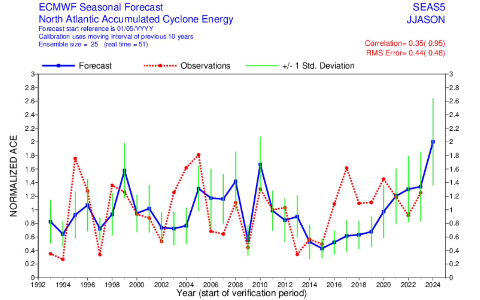
Enlarge / European model seasonal forecast for Atlantic tropical activity over time.
ECMWF
As the center’s time series indicates, the seasonal forecast is far from perfect. (Most hurricane season forecasting, it must be said, is part art and part science.) But it is one of the best forecasts available, and for 2024, it made its highest prediction ever. The European model calls for an “accumulated cyclone energy” forecast twice as high as a normal year. This means that the duration and intensity of tropical activity are expected to double that of a typical season.
As always, a busy hurricane season does not guarantee that any part of the United States, Mexico, Central America, or the Caribbean Islands will get hit. Rather, it simply loads the dice, increasing the odds of a strike during a season. As a coastal resident, I don’t particularly like those odds.